1990s Maps of Lawrence County, Mississippi
Explore 3 historic maps of Lawrence County from the 1990s. These maps offer a rare glimpse into what life looked like during the 1990s — showing old roads, neighborhoods, homes, and landmarks that have changed or disappeared over time.
Whether you're researching your family's past, planning a metal detecting trip, or studying how Lawrence County's landscape evolved across the 1990s, these high-resolution maps are a powerful tool for exploring the history of this region.
- Focus on a specific era: All maps on this page are from the 1990s, giving you a focused view of this time period.
- See what’s changed: Compare century-old streets, trails, and buildings to today's modern landscape using overlays and satellite layers.
- Research with precision: Use these maps for genealogy, historical research, land use analysis, or educational projects.
- View, download, or print: Maps are fully viewable online in high resolution, and can be downloaded or printed for your own records.
Start exploring Lawrence County's history through authentic maps from the 1990s. This is your window into the past.
Lawrence County, MS maps
(3)- 1994 Map of Laurel
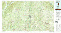
 1994 Laurel1994 Print · USGSThe piney woods of south-central Mississippi come into focus in the 1990s, centered on the timber and industrial hub of Laurel. Genealogists and researchers can trace the rural landscape between Collins and Bay Springs or locate homesites near Ellisville and Magee.
 - 1994 Map of McComb
 1994 McComb1994 Print · USGSSouthern Mississippi's rail-and-timber country is documented here in the early nineties as the region balanced its industrial corridors with vast forest preserves. Genealogists can trace hundreds of family-named rural landmarks, from Holmesville and Chatawa to the historic Zion Hill Ch.
 - 1994 Map of Hattiesburg, 1995 Print
 1994 Hattiesburg1995 Print · USGSSouth-central Mississippi's river valleys and timberlands are seen here in the mid-1990s as the region's transport network matured. Researchers can trace rural lineages through sites like Old Pioneer Cem and Spring Cottage or explore the vast Camp Shelby Military Reservation.
End of results
Showing maps 1-3 of 3
Top cities of Lawrence County
Frequently asked questions
- What are the different types of historical maps available for Lawrence County?
- What is the oldest map of Lawrence County?
- Where can I purchase historical maps of Lawrence County for my home or office?
- Where can I download high-res historical maps of Lawrence County?
- Are there historical topographic maps available for Lawrence County?
- Is there historical aerial imagery available for Lawrence County?
- Where are historical maps of Lawrence County sourced from?