1980s Maps of Columbus AFB, Mississippi
Explore 4 historic maps of Columbus AFB from the 1980s. These maps offer a rare glimpse into what life looked like during the 1980s — showing old roads, neighborhoods, homes, and landmarks that have changed or disappeared over time.
Whether you're researching your family's past, planning a metal detecting trip, or studying how Columbus AFB's landscape evolved across the 1980s, these high-resolution maps are a powerful tool for exploring the history of this region.
- Focus on a specific era: All maps on this page are from the 1980s, giving you a focused view of this time period.
- See what’s changed: Compare century-old streets, trails, and buildings to today's modern landscape using overlays and satellite layers.
- Research with precision: Use these maps for genealogy, historical research, land use analysis, or educational projects.
- View, download, or print: Maps are fully viewable online in high resolution, and can be downloaded or printed for your own records.
Start exploring Columbus AFB's history through authentic maps from the 1980s. This is your window into the past.
Columbus AFB, MS maps
(4)- 1982 Map of West Point, 1983 Print
 1982 West Point1983 Print · USGSEastern Mississippi and western Alabama are captured in the early eighties as the river-and-rail economy evolved. Trace family roots and old township lines near West Point, Columbus Air Force Base, and the historic Natchez Trace Parkway.
 - 1984 Map of West Point
 1984 West Point1984 Print · USGSNorth-Central Mississippi in the mid-eighties shows a landscape defined by massive water management projects and dense timberlands. Researchers can trace the legacy of rural settlements like Geeslin Corner or the rail corridors of the Illinois Central Gulf RR near Grenada Lake.3 unique versions available
 - 1987 Map of Hamilton
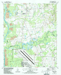 1987 Hamilton1987 Print · USGSThe Monroe and Lowndes County line in the late eighties shows a landscape of military aviation and river engineering. Trace the boundaries of Columbus Air Force Base or locate rural landmarks like Sardis Cem and Sulphur Springs Sch.
 - 1987 Map of Columbus North
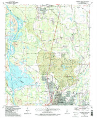 1987 Columbus North1987 Print · USGSNorthern Mississippi in the late eighties shows the rise of major water projects and military infrastructure. Trace the early layout of Columbus near the Columbus Air Force Base and historic churches like Antioch Ch.2 unique versions available
End of results
Showing maps 1-4 of 4
Top cities near Columbus AFB
- Columbus historical maps
- West Point historical maps
- Aberdeen historical maps
- Caledonia historical maps
- New Hamilton historical maps
- Artesia historical maps
Frequently asked questions
- What are the different types of historical maps available for Columbus AFB?
- What is the oldest map of Columbus AFB?
- Where can I purchase historical maps of Columbus AFB for my home or office?
- Where can I download high-res historical maps of Columbus AFB?
- Are there historical topographic maps available for Columbus AFB?
- Is there historical aerial imagery available for Columbus AFB?
- Where are historical maps of Columbus AFB sourced from?