1960s Maps of Madison County, Mississippi
Explore 16 historic maps of Madison County from the 1960s. These maps offer a rare glimpse into what life looked like during the 1960s — showing old roads, neighborhoods, homes, and landmarks that have changed or disappeared over time.
Whether you're researching your family's past, planning a metal detecting trip, or studying how Madison County's landscape evolved across the 1960s, these high-resolution maps are a powerful tool for exploring the history of this region.
- Focus on a specific era: All maps on this page are from the 1960s, giving you a focused view of this time period.
- See what’s changed: Compare century-old streets, trails, and buildings to today's modern landscape using overlays and satellite layers.
- Research with precision: Use these maps for genealogy, historical research, land use analysis, or educational projects.
- View, download, or print: Maps are fully viewable online in high resolution, and can be downloaded or printed for your own records.
Start exploring Madison County's history through authentic maps from the 1960s. This is your window into the past.
Madison County, MS maps
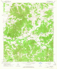
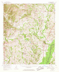
(16)- 1960 Map of Sharon, 1961 Print
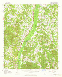
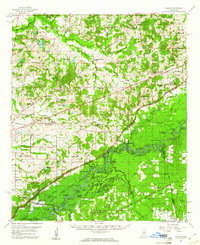 1960 Sharon1961 Print · USGSMadison County in the early sixties sits at a crossroads as the Pearl River Valley Reservoir begins to take shape. Genealogists and local historians can trace rural roots through landmarks like Zion Chapel Cem, the Sacred Heart Mission, and small hubs like Farmhaven.2 unique versions available
 - 1961 Map of Jackson
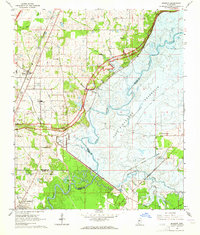
 1961 Jackson1961 Print · USGSThe Lower Mississippi Delta and the state capital area are captured here during the post-war era of infrastructure expansion. Researchers can trace the complex river oxbows and rail lines connecting Vicksburg, Yazoo City, and the Illinois Central Railroad network.
 - 1961 Map of Carthage, 1962 Print
 1961 Carthage1962 Print · USGSLeake County and the central Mississippi timberlands are captured here in the early sixties, showing the area as the Bienville National Forest and local rail lines defined the economy. Genealogists can trace family roots through numerous sites like Tribulation Cem, Free Mission Ch, and Ofahoma.3 unique versions available
 - 1961 Map of Canton, 1963 Print
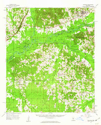
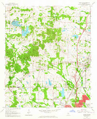
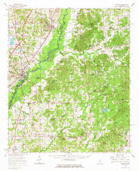
 1961 Canton1963 Print · USGSMadison County at the start of the 1960s reveals a transition from the historic rail hub of Canton to the bottomlands of the Big Black River. Genealogists and local historians can trace rural family roots at Mt Pisgah Cem, Livingston, and Campbell Chapel.3 unique versions available
 - 1962 Map of Jackson
 1962 Jackson1962 Print · USGSThe Mississippi Delta and the state capital region are mapped here in the early sixties, showing a landscape defined by the great river and the growing city of JACKSON. Genealogists can trace family roots through numerous landmarks like Cedar Hill Cem, rural stops on the Illinois Central RR, and historic sites like Champion Hill.2 unique versions available
 - 1962 Map of Flora, 1964 Print
 1962 Flora1964 Print · USGSMadison and Yazoo counties in the early sixties reveal a landscape of river-bottom farms and emerging industry along the rail lines. Local historians can trace old community ties through sites like Coxs Ferry, Kearney Park, and Old Liberty Ch Cem.2 unique versions available
 - 1962 Map of Thomastown, 1964 Print
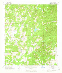
 1962 Thomastown1964 Print · USGSLeake County was a landscape of creek-side settlements and rural parishes in the early sixties. Genealogists can trace family footprints through dozens of local landmarks like Ellington Cem, Greer High Sch, and Cedar Grove Ch.
 - 1963 Map of Madison, 1964 Print
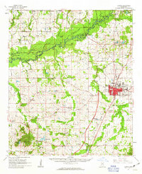
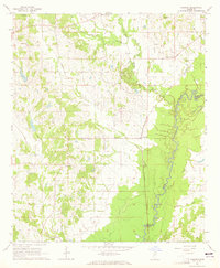
 1963 Madison1964 Print · USGSThe area around Madison and Ridgeland appears in the early sixties just as the Ross Barnett Reservoir was being formed. Researchers can trace land tracts near the Natchez Trace Parkway or locate family sites like True Vine Cem and Bennett Chapel.3 unique versions available
 - 1963 Map of Ridgeland, 1964 Print
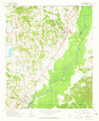
 1963 Ridgeland1964 Print · USGSMadison County and the northern outskirts of Jackson appear here in the early sixties, as suburban growth begins to reach toward the historic Trace. Genealogists and historians can trace institutional roots at Tougaloo Southern Christian College or locate family markers at Montgomery Cem and Green Cem.3 unique versions available
 - 1964 Map of Camden, 1965 Print
 1964 Camden1965 Print · USGSMadison County's rural communities are meticulously recorded in the mid-1960s, showing the intersection of local history and old land boundaries. Researchers can trace the Old Treaty Boundary and locate family landmarks like Shiloh Cem and Mt Mary Ch.3 unique versions available
 - 1964 Map of Newport, 1965 Print
 1964 Newport1965 Print · USGSThe Attala and Madison County line comes alive in the mid-sixties, showing a landscape defined by small churches and early boundaries. Genealogists and historians can trace family locations near Newport, the Sallis Lookout Tower, and the Old Indian Boundary.2 unique versions available
 - 1964 Map of Vaughan, 1965 Print
 1964 Vaughan1965 Print · USGSYazoo and Madison Counties are captured here in the mid-1960s, showing a rural landscape organized around the Illinois Central line. Genealogists can locate family landmarks like Strangers Home Cem, Day Cem, and churches such as Bell Chapel.3 unique versions available
 - 1964 Map of Goodman, 1965 Print
 1964 Goodman1965 Print · USGSThe mid-Mississippi corridor at the dawn of the 1960s highlights a landscape shaped by the Big Black River and the storied Illinois Central railroad. Genealogists can trace family footprints through sites like Holmes County Junior College, Bethlehem Ch, and Quiet Ridge Cem.2 unique versions available
 - 1965 Map of Meridian
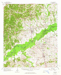
 1965 Meridian1965 Print · USGSEast Mississippi and West Alabama are mapped here in the mid-sixties as the region's modern highway and reservoir systems began to take shape. Researchers can trace rural lineages through local landmarks like Prince Chapel and Tuscahoma Landing, or follow the historic Gulf Mobile & Ohio rail lines.
 - 1966 Map of Goodman, 1967 Print
 1966 Goodman1967 Print · USGSMid-century Mississippi hill country and river bottomlands come alive here in the mid-1960s as small farming communities and timberlands span four counties. Genealogists can trace family roots through dozen of rural landmarks like Soule Chapel, Quiet Ridge Cem, and the Holmes County Junior College.
 - 1966 Map of Vaughan, 1967 Print
 1966 Vaughan1967 Print · USGSCentral Mississippi's rural landscape comes alive in the mid-1960s, showing the intersection of rail and river life. Researchers can trace family roots at Piney Springs Cem, Holy City, and schools like Linwood Sch.2 unique versions available
End of results
Showing maps 1-16 of 16
Top cities of Madison County
- Madison historical maps
- Ridgeland historical maps
- Canton historical maps
- Gluckstadt historical maps
- Flora historical maps
Frequently asked questions
- What are the different types of historical maps available for Madison County?
- What is the oldest map of Madison County?
- Where can I purchase historical maps of Madison County for my home or office?
- Where can I download high-res historical maps of Madison County?
- Are there historical topographic maps available for Madison County?
- Is there historical aerial imagery available for Madison County?
- Where are historical maps of Madison County sourced from?