1990s Maps of Madison County, Mississippi
Explore 3 historic maps of Madison County from the 1990s. These maps offer a rare glimpse into what life looked like during the 1990s — showing old roads, neighborhoods, homes, and landmarks that have changed or disappeared over time.
Whether you're researching your family's past, planning a metal detecting trip, or studying how Madison County's landscape evolved across the 1990s, these high-resolution maps are a powerful tool for exploring the history of this region.
- Focus on a specific era: All maps on this page are from the 1990s, giving you a focused view of this time period.
- See what’s changed: Compare century-old streets, trails, and buildings to today's modern landscape using overlays and satellite layers.
- Research with precision: Use these maps for genealogy, historical research, land use analysis, or educational projects.
- View, download, or print: Maps are fully viewable online in high resolution, and can be downloaded or printed for your own records.
Start exploring Madison County's history through authentic maps from the 1990s. This is your window into the past.
Madison County, MS maps
(3)- 1994 Map of Carthage
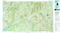 1994 Carthage1994 Print · USGSCentral Mississippi in the mid-nineties is a region of dense river bottoms and historic travel ways. Genealogists can trace family names and small-town roots across the Choctaw Indian Reservation or follow the path of the Natchez Trace Parkway past Carthage and Walnut Grove.
 - 1998 Map of Ridgeland
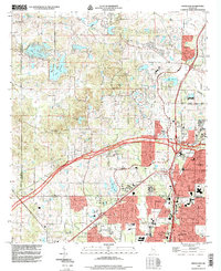 1998 Ridgeland1998 Print · USGSGreater Jackson's northern corridor comes alive in the late nineties as residential growth meets historic institutions. Genealogists and researchers can locate Tougaloo College, Montgomery Cem, and the path of the NATCHEZ TRACE PARKWAY.
 - 1998 Map of Madison
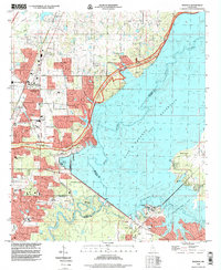 1998 Madison1998 Print · USGSMadison and Ridgeland undergo rapid suburban growth just before the turn of the millennium as the state capital expands north. Genealogists and local researchers can trace legacy landmarks like Jessamine Cem, the historic Natchez Trace Parkway, and Mule Jail Lake.
End of results
Showing maps 1-3 of 3
Top cities of Madison County
- Madison historical maps
- Ridgeland historical maps
- Canton historical maps
- Gluckstadt historical maps
- Flora historical maps
Frequently asked questions
- What are the different types of historical maps available for Madison County?
- What is the oldest map of Madison County?
- Where can I purchase historical maps of Madison County for my home or office?
- Where can I download high-res historical maps of Madison County?
- Are there historical topographic maps available for Madison County?
- Is there historical aerial imagery available for Madison County?
- Where are historical maps of Madison County sourced from?