1960s Maps of Madison, Mississippi
Explore 5 historic maps of Madison from the 1960s. These maps offer a rare glimpse into what life looked like during the 1960s — showing old roads, neighborhoods, homes, and landmarks that have changed or disappeared over time.
Whether you're researching your family's past, planning a metal detecting trip, or studying how Madison's landscape evolved across the 1960s, these high-resolution maps are a powerful tool for exploring the history of this region.
- Focus on a specific era: All maps on this page are from the 1960s, giving you a focused view of this time period.
- See what’s changed: Compare century-old streets, trails, and buildings to today's modern landscape using overlays and satellite layers.
- Research with precision: Use these maps for genealogy, historical research, land use analysis, or educational projects.
- View, download, or print: Maps are fully viewable online in high resolution, and can be downloaded or printed for your own records.
Start exploring Madison's history through authentic maps from the 1960s. This is your window into the past.
Madison, MS maps
(5)- 1961 Map of Jackson
 1961 Jackson1961 Print · USGSThe Lower Mississippi Delta and the state capital area are captured here during the post-war era of infrastructure expansion. Researchers can trace the complex river oxbows and rail lines connecting Vicksburg, Yazoo City, and the Illinois Central Railroad network.
 - 1961 Map of Canton, 1963 Print
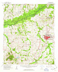 1961 Canton1963 Print · USGSMadison County at the start of the 1960s reveals a transition from the historic rail hub of Canton to the bottomlands of the Big Black River. Genealogists and local historians can trace rural family roots at Mt Pisgah Cem, Livingston, and Campbell Chapel.3 unique versions available
 - 1962 Map of Jackson
 1962 Jackson1962 Print · USGSThe Mississippi Delta and the state capital region are mapped here in the early sixties, showing a landscape defined by the great river and the growing city of JACKSON. Genealogists can trace family roots through numerous landmarks like Cedar Hill Cem, rural stops on the Illinois Central RR, and historic sites like Champion Hill.2 unique versions available
 - 1963 Map of Madison, 1964 Print
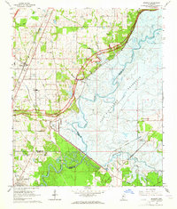 1963 Madison1964 Print · USGSThe area around Madison and Ridgeland appears in the early sixties just as the Ross Barnett Reservoir was being formed. Researchers can trace land tracts near the Natchez Trace Parkway or locate family sites like True Vine Cem and Bennett Chapel.3 unique versions available
 - 1963 Map of Ridgeland, 1964 Print
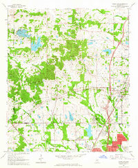 1963 Ridgeland1964 Print · USGSMadison County and the northern outskirts of Jackson appear here in the early sixties, as suburban growth begins to reach toward the historic Trace. Genealogists and historians can trace institutional roots at Tougaloo Southern Christian College or locate family markers at Montgomery Cem and Green Cem.3 unique versions available
End of results
Showing maps 1-5 of 5
Top cities near Madison
- Jackson historical maps
- Clinton historical maps
- Pearl historical maps
- Brandon historical maps
- Ridgeland historical maps
- Canton historical maps
See more
Top neighborhoods of Madison
- Stonegate historical maps
- Tidewater historical maps
- Traceland North historical maps
- Treasure Cove historical maps
- Hunters Creek historical maps
- Pecan Creek historical maps
See more
Frequently asked questions
- What are the different types of historical maps available for Madison?
- What is the oldest map of Madison?
- Where can I purchase historical maps of Madison for my home or office?
- Where can I download high-res historical maps of Madison?
- Are there historical topographic maps available for Madison?
- Is there historical aerial imagery available for Madison?
- Where are historical maps of Madison sourced from?