1970s Maps of Marshall County, Mississippi
Explore 8 historic maps of Marshall County from the 1970s. These maps offer a rare glimpse into what life looked like during the 1970s — showing old roads, neighborhoods, homes, and landmarks that have changed or disappeared over time.
Whether you're researching your family's past, planning a metal detecting trip, or studying how Marshall County's landscape evolved across the 1970s, these high-resolution maps are a powerful tool for exploring the history of this region.
- Focus on a specific era: All maps on this page are from the 1970s, giving you a focused view of this time period.
- See what’s changed: Compare century-old streets, trails, and buildings to today's modern landscape using overlays and satellite layers.
- Research with precision: Use these maps for genealogy, historical research, land use analysis, or educational projects.
- View, download, or print: Maps are fully viewable online in high resolution, and can be downloaded or printed for your own records.
Start exploring Marshall County's history through authentic maps from the 1970s. This is your window into the past.
Marshall County, MS maps
(8)- 1971 Map of Byhalia, 1973 Print
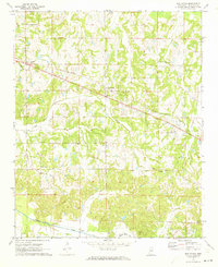
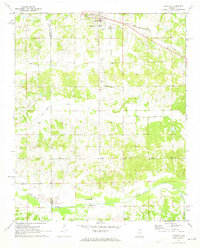 1971 Byhalia1973 Print · USGSByhalia and its rural surrounds in the early 1970s show a landscape of railroad-driven growth and traditional southern church communities. Local researchers can pinpoint family burial sites at Watkins Cem or trace the old rail corridor of the St Louis - San Francisco through Coal Oil Corner.
 - 1971 Map of Marianna, 1973 Print
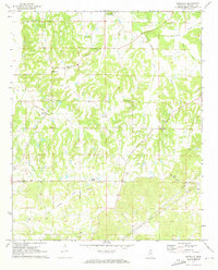 1971 Marianna1973 Print · USGSMarshall County rural life remains centered on historic church congregations and family lands during the early 1970s. Genealogists can trace family connections through numerous sites like Yarbrough Chapel, Nunnally Cem, and the small settlement of Galena.
 - 1971 Map of Wyatte, 1973 Print
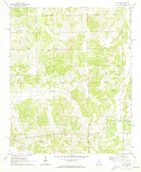 1971 Wyatte1973 Print · USGSThe Marshall and Tate County borderlands come to life in the early 1970s, showcasing a network of rural settlements and crossroad communities. Trace family history through Wyatte, Chulahoma, and local landmarks like Jamieson Chapel or Grubb Hill Cem.2 unique versions available
 - 1971 Map of Laws Hill, 1973 Print
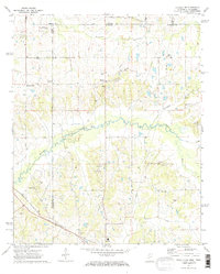
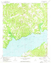 1971 Laws Hill1973 Print · USGSUpper Lafayette County and the Sardis Lake shoreline are captured here in the early seventies, as the river valley's transition to a major reservoir was well-established. Genealogists can trace family sites at Abbeville Cem, Mt Moriah Ch, and the historic Wyatt Cem near the water.2 unique versions available
 - 1971 Map of Red Banks, 1973 Print
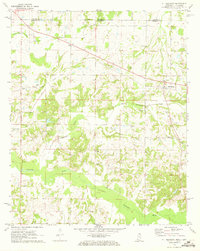
 1971 Red Banks1973 Print · USGSMarshall County in the early seventies is captured here as a landscape of small rail-side settlements and rural parishes. Researchers can locate family landmarks like Wesley Chapel Cem, the old depot site at Victoria, and Antioch Ch.
 - 1971 Map of Mt. Pleasant, 1973 Print
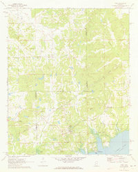
 1971 Mt. Pleasant1973 Print · USGSThe Tennessee-Mississippi borderlands appear here in the early 1970s, showing a rural landscape of small churches and family burial sites. Researchers can trace local history through features like Mt Pleasant, Carey Chapel, and Carington Cem along the Coldwater River.
 - 1971 Map of Byhalia NW, 1973 Print
 1971 Byhalia NW1973 Print · USGSThe Tennessee-Mississippi borderlands appear in the early 1970s as a landscape of small rural settlements and winding river bottoms. Genealogists can locate family landmarks like Handy Corner, McGehee Cem, and the St Louis San Francisco rail line.2 unique versions available
 - 1971 Map of Tyro, 1973 Print
 1971 Tyro1973 Print · USGSThe rural borderlands of Lafayette, Tate, and Marshall counties are captured here in the early 1970s before modern development altered these small communities. Researchers can trace family sites at Mt Patient Cem, Langstons Cem, and rural hubs like Harmontown and Tyro.2 unique versions available
End of results
Showing maps 1-8 of 8
Top cities of Marshall County
Frequently asked questions
- What are the different types of historical maps available for Marshall County?
- What is the oldest map of Marshall County?
- Where can I purchase historical maps of Marshall County for my home or office?
- Where can I download high-res historical maps of Marshall County?
- Are there historical topographic maps available for Marshall County?
- Is there historical aerial imagery available for Marshall County?
- Where are historical maps of Marshall County sourced from?