1960s Maps of Marshall County, Mississippi
Explore 6 historic maps of Marshall County from the 1960s. These maps offer a rare glimpse into what life looked like during the 1960s — showing old roads, neighborhoods, homes, and landmarks that have changed or disappeared over time.
Whether you're researching your family's past, planning a metal detecting trip, or studying how Marshall County's landscape evolved across the 1960s, these high-resolution maps are a powerful tool for exploring the history of this region.
- Focus on a specific era: All maps on this page are from the 1960s, giving you a focused view of this time period.
- See what’s changed: Compare century-old streets, trails, and buildings to today's modern landscape using overlays and satellite layers.
- Research with precision: Use these maps for genealogy, historical research, land use analysis, or educational projects.
- View, download, or print: Maps are fully viewable online in high resolution, and can be downloaded or printed for your own records.
Start exploring Marshall County's history through authentic maps from the 1960s. This is your window into the past.
Marshall County, MS maps
(6)- 1964 Map of Waterford, 1965 Print
 1964 Waterford1965 Print · USGSWayne County during the mid-sixties reveals a landscape of national forest land and emerging industry. Researchers can locate remote family sites like Shows Cem or trace the early Thompson Creek Oil Field and Big Creek Lookout Tower.
 - 1964 Map of Holly Springs SE, 1966 Print
 1964 Holly Springs SE1966 Print · USGSNorthern Mississippi in the mid-sixties reveals a landscape defined by the Holly Springs National Forest and the Illinois Central rail line. Researchers can trace rural landmarks from Hudsonville to Chestnut Grove Cem and Royston Chapel.2 unique versions available
 - 1965 Map of Slayden, 1966 Print
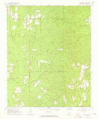
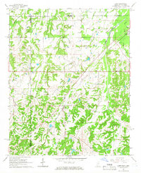
 1965 Slayden1966 Print · USGSSpanning the Tennessee and Mississippi border in the 1960s, this area reveals a landscape of rural school districts and family cemeteries. Trace the locations of historic landmarks like Early Grove, Sand Flats Jr High Sch, and the Pittman Cem.2 unique versions available
 - 1965 Map of Holly Springs, 1966 Print
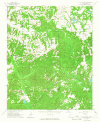
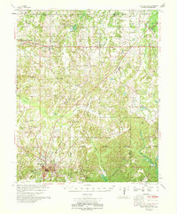
 1965 Holly Springs1966 Print · USGSHolly Springs was a prominent hub of education and rail at the height of the mid-sixties. Genealogists and historians can trace family landmarks like Hillcrest Cem, McAlexander Cem, and the grounds of Mississippi Industrial College.2 unique versions available
 - 1965 Map of Lamar, 1966 Print
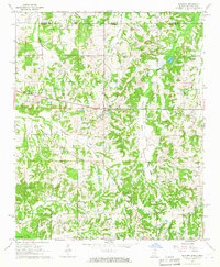
 1965 Lamar1966 Print · USGSBenton County, Mississippi, and Fayette County, Tennessee, meet in the mid-1960s along a landscape defined by the ILLINOIS CENTRAL railroad. Researchers can trace family roots through numerous local sites like Lamar Cem, Hickory Hill Cem, and Berry Chapel.2 unique versions available
 - 1969 Map of Holly Springs
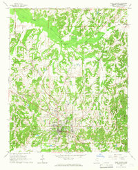
 1969 Holly Springs1969 Print · USGSNorthern Mississippi and the Tennessee borderlands are detailed here in the late sixties, centered on the rail crossroads of Holly Springs. Genealogists and local historians can trace hundreds of rural landmarks, including Early Grove Cem, Roberts Chapel, and the Sand Flats Jr High Sch.
End of results
Showing maps 1-6 of 6
Top cities of Marshall County
Frequently asked questions
- What are the different types of historical maps available for Marshall County?
- What is the oldest map of Marshall County?
- Where can I purchase historical maps of Marshall County for my home or office?
- Where can I download high-res historical maps of Marshall County?
- Are there historical topographic maps available for Marshall County?
- Is there historical aerial imagery available for Marshall County?
- Where are historical maps of Marshall County sourced from?