1960s Maps of Amory, Mississippi
Explore 5 historic maps of Amory from the 1960s. These maps offer a rare glimpse into what life looked like during the 1960s — showing old roads, neighborhoods, homes, and landmarks that have changed or disappeared over time.
Whether you're researching your family's past, planning a metal detecting trip, or studying how Amory's landscape evolved across the 1960s, these high-resolution maps are a powerful tool for exploring the history of this region.
- Focus on a specific era: All maps on this page are from the 1960s, giving you a focused view of this time period.
- See what’s changed: Compare century-old streets, trails, and buildings to today's modern landscape using overlays and satellite layers.
- Research with precision: Use these maps for genealogy, historical research, land use analysis, or educational projects.
- View, download, or print: Maps are fully viewable online in high resolution, and can be downloaded or printed for your own records.
Start exploring Amory's history through authentic maps from the 1960s. This is your window into the past.
Amory, MS maps
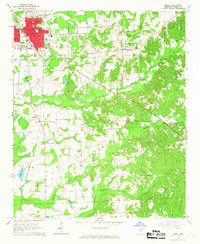
(5)- 1963 Map of West Point
 1963 West Point1963 Print · USGSEastern Mississippi and western Alabama are captured in the early sixties as industrial centers and rail lines connected the Black Prairie to the hills. Genealogists and historians can trace family-named watercourses and the early footprints of Starkville, Columbus, and the Noxubee National Wildlife Refuge.2 unique versions available
 - 1966 Map of Smithville, 1967 Print
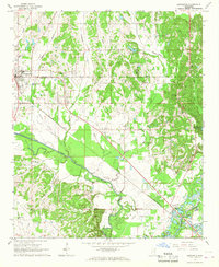
 1966 Smithville1967 Print · USGSMonroe and Itawamba counties appear here in the mid-1960s, a landscape defined by the winding Tombigbee River and historic land lines. Genealogists can locate family landmarks like Dunlap Cem, Bethel Ch, and the distinct paths of the Old Indian Boundary.2 unique versions available
 - 1966 Map of Amory, 1967 Print
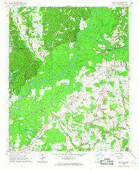
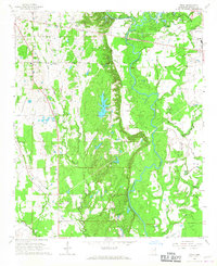
 1966 Amory1967 Print · USGSAmory and its surrounding Monroe County hill country appear here during the mid-1960s, showing the intersection of rail-line industry and rural life. Researchers can trace family roots at numerous rural landmarks, including St Paul Ch, Camp Cem, and the Monroe County Airport.3 unique versions available
 - 1966 Map of Wren, 1967 Print
 1966 Wren1967 Print · USGSMonroe County was defined by its river-bottom industry and quiet rural settlements during the mid-1960s. Genealogists and historians can trace family roots through numerous sites like Grady's Chapel, Mound Cem, and the historic Indian Treaty Boundary.2 unique versions available
 - 1966 Map of Nettleton, 1967 Print
 1966 Nettleton1967 Print · USGSNettleton and the Lee-Monroe county line are shown here in the mid-1960s, prior to significant modern development along the river. Genealogists can trace family landmarks like Siloam Sch, Union View Ch, and cemeteries such as Williams Cem and Goodwin Cem.2 unique versions available
End of results
Showing maps 1-5 of 5
Top cities near Amory
- Tupelo historical maps
- Aberdeen historical maps
- Verona historical maps
- Nettleton historical maps
- Shannon historical maps
- Plantersville historical maps
See more
Top neighborhoods of Amory
- Carroll Subdivision historical maps
- Colonial Acres historical maps
- Easthaven historical maps
- Gardenspot Subdivision historical maps
- Glenwood historical maps
- Hedgemoor historical maps
See more
Frequently asked questions
- What are the different types of historical maps available for Amory?
- What is the oldest map of Amory?
- Where can I purchase historical maps of Amory for my home or office?
- Where can I download high-res historical maps of Amory?
- Are there historical topographic maps available for Amory?
- Is there historical aerial imagery available for Amory?
- Where are historical maps of Amory sourced from?