1980s Maps of Noxubee County, Mississippi
Explore 6 historic maps of Noxubee County from the 1980s. These maps offer a rare glimpse into what life looked like during the 1980s — showing old roads, neighborhoods, homes, and landmarks that have changed or disappeared over time.
Whether you're researching your family's past, planning a metal detecting trip, or studying how Noxubee County's landscape evolved across the 1980s, these high-resolution maps are a powerful tool for exploring the history of this region.
- Focus on a specific era: All maps on this page are from the 1980s, giving you a focused view of this time period.
- See what’s changed: Compare century-old streets, trails, and buildings to today's modern landscape using overlays and satellite layers.
- Research with precision: Use these maps for genealogy, historical research, land use analysis, or educational projects.
- View, download, or print: Maps are fully viewable online in high resolution, and can be downloaded or printed for your own records.
Start exploring Noxubee County's history through authentic maps from the 1980s. This is your window into the past.
Noxubee County, MS maps
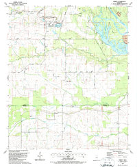
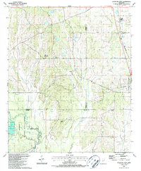
(6)- 1984 Map of De Kalb
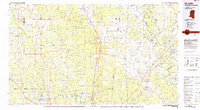 1984 De Kalb1984 Print · USGSThe Mississippi-Alabama borderlands come into focus in the 1980s, where the river-and-rail economy meets military and tribal lands. Researchers can trace rural lineages across the Choctaw Indian Reservation or through the rail towns of Scooba and De Kalb.2 unique versions available
 - 1984 Map of West Point
 1984 West Point1984 Print · USGSNorth-Central Mississippi in the mid-eighties shows a landscape defined by massive water management projects and dense timberlands. Researchers can trace the legacy of rural settlements like Geeslin Corner or the rail corridors of the Illinois Central Gulf RR near Grenada Lake.3 unique versions available
 - 1987 Map of Trinity
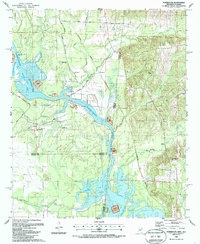
 1987 Trinity1987 Print · USGSLowndes and Noxubee Counties appear in the late 1980s as the river landscape transitions to a modern waterway. Genealogists and local historians can locate many rural landmarks, from the St John Ch and Plum Grove settlement to the docks at Camp Pratt.
 - 1987 Map of Forreston
 1987 Forreston1987 Print · USGSThe Mississippi and Alabama borderlands appear here in the late 1980s, just as the river system was being reshaped by the Tennessee-Tombigbee project. Local researchers can trace family roots through Mt Avery Ch, Toliver Cem, and the rural settlement of Forreston.
 - 1987 Map of Crawford East
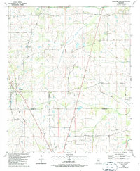 1987 Crawford East1987 Print · USGSThe rural border of Lowndes and Noxubee Counties in the late 1980s reveals a community centered on the town of Crawford and the Gulf Mobile and Mississippi railroad. Genealogists can trace family landmarks and burial grounds like Ledbetter Cem and St James Ch.
 - 1987 Map of Crawford West
 1987 Crawford West1987 Print · USGSOktibbeha County in the late 1980s reveals a landscape defined by the expansive Noxubee National Wildlife Refuge and small rural communities. Trace local family roots and early settlements through landmarks like Crawford, B L Moor High Sch, and Union Chapel.
End of results
Showing maps 1-6 of 6
Top cities of Noxubee County
Frequently asked questions
- What are the different types of historical maps available for Noxubee County?
- What is the oldest map of Noxubee County?
- Where can I purchase historical maps of Noxubee County for my home or office?
- Where can I download high-res historical maps of Noxubee County?
- Are there historical topographic maps available for Noxubee County?
- Is there historical aerial imagery available for Noxubee County?
- Where are historical maps of Noxubee County sourced from?