1960s Maps of Oktibbeha County, Mississippi
Explore 5 historic maps of Oktibbeha County from the 1960s. These maps offer a rare glimpse into what life looked like during the 1960s — showing old roads, neighborhoods, homes, and landmarks that have changed or disappeared over time.
Whether you're researching your family's past, planning a metal detecting trip, or studying how Oktibbeha County's landscape evolved across the 1960s, these high-resolution maps are a powerful tool for exploring the history of this region.
- Focus on a specific era: All maps on this page are from the 1960s, giving you a focused view of this time period.
- See what’s changed: Compare century-old streets, trails, and buildings to today's modern landscape using overlays and satellite layers.
- Research with precision: Use these maps for genealogy, historical research, land use analysis, or educational projects.
- View, download, or print: Maps are fully viewable online in high resolution, and can be downloaded or printed for your own records.
Start exploring Oktibbeha County's history through authentic maps from the 1960s. This is your window into the past.
Oktibbeha County, MS maps
(5)- 1963 Map of West Point
 1963 West Point1963 Print · USGSEastern Mississippi and western Alabama are captured in the early sixties as industrial centers and rail lines connected the Black Prairie to the hills. Genealogists and historians can trace family-named watercourses and the early footprints of Starkville, Columbus, and the Noxubee National Wildlife Refuge.2 unique versions available
 - 1965 Map of Starkville, 1966 Print
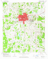 1965 Starkville1966 Print · USGSStarkville and the neighboring college grounds are captured here in the mid-sixties during a period of steady institutional growth. Genealogists and historians can trace family locations near landmarks like Odd Fellows Cem or old rural schools such as Beat 1 Sch.4 unique versions available
 - 1965 Map of Bluff Lake, 1966 Print
 1965 Bluff Lake1966 Print · USGSThe Oktibbeha County wetlands come into focus in the mid-sixties as conservation efforts shaped the local landscape. Genealogists and researchers can trace family landmarks like Bethel Ch and Noxubee Cem alongside the managed waters of Bluff Lake.
 - 1965 Map of Longview, 1966 Print
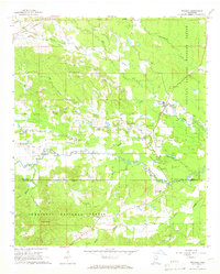
 1965 Longview1966 Print · USGSOktibbeha County’s rural character is on full display in the mid-1960s, showing a landscape shaped by local churches and the rail line. Genealogists and historians can locate family landmarks like Lost Cem, Bethel Ch, and the old rail stop at Longview.3 unique versions available
 - 1965 Map of Bradley, 1966 Print
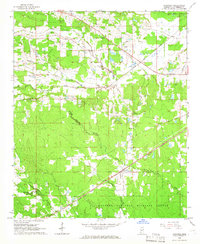
 1965 Bradley1966 Print · USGSOktibbeha and Winston Counties are shown in the mid-1960s, a time when the rural landscape was defined by the Noxubee River and the Illinois Central railroad. Researchers can locate family landmarks like Pughs Mill Ch, McClelland Cem, and the old settlement of Bradley.3 unique versions available
End of results
Showing maps 1-5 of 5
Top cities of Oktibbeha County
Frequently asked questions
- What are the different types of historical maps available for Oktibbeha County?
- What is the oldest map of Oktibbeha County?
- Where can I purchase historical maps of Oktibbeha County for my home or office?
- Where can I download high-res historical maps of Oktibbeha County?
- Are there historical topographic maps available for Oktibbeha County?
- Is there historical aerial imagery available for Oktibbeha County?
- Where are historical maps of Oktibbeha County sourced from?