1970s Maps of Oktibbeha County, Mississippi
Explore 3 historic maps of Oktibbeha County from the 1970s. These maps offer a rare glimpse into what life looked like during the 1970s — showing old roads, neighborhoods, homes, and landmarks that have changed or disappeared over time.
Whether you're researching your family's past, planning a metal detecting trip, or studying how Oktibbeha County's landscape evolved across the 1970s, these high-resolution maps are a powerful tool for exploring the history of this region.
- Focus on a specific era: All maps on this page are from the 1970s, giving you a focused view of this time period.
- See what’s changed: Compare century-old streets, trails, and buildings to today's modern landscape using overlays and satellite layers.
- Research with precision: Use these maps for genealogy, historical research, land use analysis, or educational projects.
- View, download, or print: Maps are fully viewable online in high resolution, and can be downloaded or printed for your own records.
Start exploring Oktibbeha County's history through authentic maps from the 1970s. This is your window into the past.
Oktibbeha County, MS maps
(3)- 1972 Map of Maben, 1974 Print
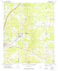 1972 Maben1974 Print · USGSMaben and Mathiston appear as active rail-and-road junctions in the early seventies, positioned at the convergence of four North Mississippi counties. Local historians can trace old community centers like Cumberland, dozens of country churches including Double Springs Ch, and the route of the Natchez Trace Parkway.
 - 1972 Map of Double Springs, 1975 Print
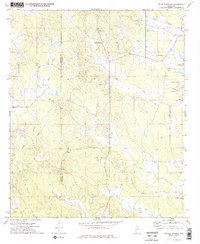 1972 Double Springs1975 Print · USGSThe rural borderlands of Choctaw and Oktibbeha counties are documented here in the early seventies, centered on the community of Double Springs. Genealogists and local historians can locate several rural landmarks, including Mt Olive Cem, McMinn Cem, and the Old Self Creek Ch.2 unique versions available
 - 1972 Map of Sturgis, 1975 Print
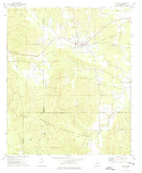 1972 Sturgis1975 Print · USGSThe town of Sturgis and its surrounding timberlands are captured here in the early seventies as the railroad still connected the local economy. Genealogists can trace family names through landmarks like Old Sturgis Cem, Boyd Chapel, and the Tombigbee Lookout Tower.
End of results
Showing maps 1-3 of 3
Top cities of Oktibbeha County
Frequently asked questions
- What are the different types of historical maps available for Oktibbeha County?
- What is the oldest map of Oktibbeha County?
- Where can I purchase historical maps of Oktibbeha County for my home or office?
- Where can I download high-res historical maps of Oktibbeha County?
- Are there historical topographic maps available for Oktibbeha County?
- Is there historical aerial imagery available for Oktibbeha County?
- Where are historical maps of Oktibbeha County sourced from?