1960s Maps of Prentiss County, Mississippi
Explore 4 historic maps of Prentiss County from the 1960s. These maps offer a rare glimpse into what life looked like during the 1960s — showing old roads, neighborhoods, homes, and landmarks that have changed or disappeared over time.
Whether you're researching your family's past, planning a metal detecting trip, or studying how Prentiss County's landscape evolved across the 1960s, these high-resolution maps are a powerful tool for exploring the history of this region.
- Focus on a specific era: All maps on this page are from the 1960s, giving you a focused view of this time period.
- See what’s changed: Compare century-old streets, trails, and buildings to today's modern landscape using overlays and satellite layers.
- Research with precision: Use these maps for genealogy, historical research, land use analysis, or educational projects.
- View, download, or print: Maps are fully viewable online in high resolution, and can be downloaded or printed for your own records.
Start exploring Prentiss County's history through authentic maps from the 1960s. This is your window into the past.
Prentiss County, MS maps
(4)- 1965 Map of Paden SE, 1966 Print
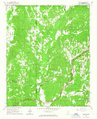 1965 Paden SE1966 Print · USGSThe Prentiss and Tishomingo county line area appears here in the mid-sixties, dominated by rural creek bottoms and family-named ridges. Trace the path of the Natchez Trace Parkway while it was Under Construction near Trollinger Cem and Mt Zion Ch.
 - 1965 Map of Fulton NE, 1966 Print
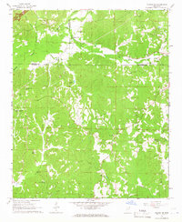 1965 Fulton NE1966 Print · USGSItawamba County and the surrounding tri-county area are shown in the mid-1960s as the modern parkway system began to reshape the landscape. Genealogists can locate numerous rural landmarks such as Moores Mill, Old Bethel Ch, and the Walker House Cem Ch.
 - 1965 Map of Marietta, 1966 Print
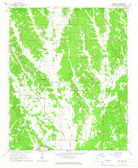 1965 Marietta1966 Print · USGSNorth Mississippi's rural landscape comes into focus during the mid-sixties, centered on the Marietta community and the Natchez Trace Parkway. Researchers can trace old family sites and local landmarks like Hobo Station, Zions Rest Ch, and the Marietta Lookout Tower.2 unique versions available
 - 1965 Map of Kirkville, 1966 Print
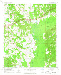 1965 Kirkville1966 Print · USGSNortheast Mississippi rural life and early parkway development are captured here in the mid-sixties. Trace family history through Kirkville and Sandy Springs, or find old community sites like Houston Sch and Gilmers Chapel.2 unique versions available
End of results
Showing maps 1-4 of 4
Top cities of Prentiss County
Frequently asked questions
- What are the different types of historical maps available for Prentiss County?
- What is the oldest map of Prentiss County?
- Where can I purchase historical maps of Prentiss County for my home or office?
- Where can I download high-res historical maps of Prentiss County?
- Are there historical topographic maps available for Prentiss County?
- Is there historical aerial imagery available for Prentiss County?
- Where are historical maps of Prentiss County sourced from?