1930s Maps of Prentiss County, Mississippi
Explore 3 historic maps of Prentiss County from the 1930s. These maps offer a rare glimpse into what life looked like during the 1930s — showing old roads, neighborhoods, homes, and landmarks that have changed or disappeared over time.
Whether you're researching your family's past, planning a metal detecting trip, or studying how Prentiss County's landscape evolved across the 1930s, these high-resolution maps are a powerful tool for exploring the history of this region.
- Focus on a specific era: All maps on this page are from the 1930s, giving you a focused view of this time period.
- See what’s changed: Compare century-old streets, trails, and buildings to today's modern landscape using overlays and satellite layers.
- Research with precision: Use these maps for genealogy, historical research, land use analysis, or educational projects.
- View, download, or print: Maps are fully viewable online in high resolution, and can be downloaded or printed for your own records.
Start exploring Prentiss County's history through authentic maps from the 1930s. This is your window into the past.
Prentiss County, MS maps
(3)- 1935 Map of Holcut
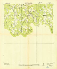 1935 Holcut1935 Print · USGSNortheast Mississippi was undergoing significant federal study in the mid-1930s as the railroad and river systems defined local life. Researchers can locate the community centers of the day, from the town of Holcut to rural landmarks like Lebanon Ch and Liberty Sch.
 - 1935 Map of Leedy
 1935 Leedy1935 Print · USGSIn the mid-1930s, the Tishomingo County countryside was a landscape of small rail spurs and country churches centered around Burnsville. Researchers can locate vanished rural landmarks such as Rolands Mill Sch, Opossum Trot Cem, and the Illinois Central rail line.
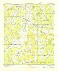
 - 1935 Map of Glens
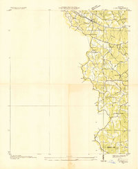 1935 Glens1935 Print · USGSNortheastern Mississippi at the height of the mid-1930s reveals a landscape defined by crossing rail lines and rural church communities. Genealogists can trace family roots through sites like Cooks Chapel, the Glen PO, and the Zion Sch near the Alcorn Co Prentiss Co line.
End of results
Showing maps 1-3 of 3
Top cities of Prentiss County
Frequently asked questions
- What are the different types of historical maps available for Prentiss County?
- What is the oldest map of Prentiss County?
- Where can I purchase historical maps of Prentiss County for my home or office?
- Where can I download high-res historical maps of Prentiss County?
- Are there historical topographic maps available for Prentiss County?
- Is there historical aerial imagery available for Prentiss County?
- Where are historical maps of Prentiss County sourced from?