
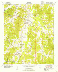
1935 Map of Holcut
USGS Topo · Published 1935About this map
Holcut serves as a central hub in this northeast Mississippi landscape, situated along the Illinois Central railroad corridor. Compiled from aerial photographs and field examinations in 1935, the map reveals a rural topography defined by the winding course of Yellow Creek and the many small drainages that feed into it, such as Cripple Deer Creek and Hurricane Creek. The social fabric of the era is evident in the placement of community centers like Lebanon Ch, Cross Roads Ch, and schools including Clausel Hill Sch and Liberty Sch.
Find a feature on this map
14 named features on this map. Tap any name to fly to it.
Don’t see what you’re looking for? This feature index may not catch every label — zoom into the map to look around manually.
Map Details
Editions of this 1935 Holcut Map
This is the sole edition of this map. No revisions or reprints were ever made.
Other maps of this area

1911 · Iuka
USGS Topo · 1:48,000

1914 · Iuka
USGS Topo · 1:62,500

1935 · Iuka
USGS Topo · 1:24,000

1935 · Leedy
USGS Topo · 1:24,000

1935 · Glens
USGS Topo · 1:24,000

1936 · Belmont
USGS Topo · 1:24,000

1936 · Tishomingo
USGS Topo · 1:24,000

1950 · Paden
USGS Topo · 1:24,000
1950 · Burnsville
USGS Topo · 1:24,000

1950 · Glens
USGS Topo · 1:24,000