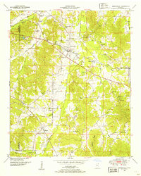
1950 Map of Burnsville
USGS Topo · Published 1954About this map
Burnsville stands as the central hub of this mid-century topographic record, situated at a junction of regional transport and drainage efforts. The landscape is defined by the early industrial and agricultural infrastructure of Tishomingo County, featuring the Southern railroad and the Yellow Creek Canal, which, along with the Coke Drainage Canal, highlights the historical management of the local watershed. Family-named landmarks and rural institutions are densely scattered across the terrain, from the Holloway School in the north to Sardis Church near the Prentiss County line.
Find a feature on this map
54 named features on this map. Tap any name to fly to it.
Don’t see what you’re looking for? This feature index may not catch every label — zoom into the map to look around manually.
Map Details
Editions of this 1950 Burnsville Map
3 editions found
Other maps of this area

1911 · Iuka
USGS Topo · 1:48,000

1914 · Iuka
USGS Topo · 1:62,500

1935 · Holcut
USGS Topo · 1:24,000

1935 · Doskie
USGS Topo · 1:24,000

1935 · Iuka
USGS Topo · 1:24,000

1935 · Leedy
USGS Topo · 1:24,000

1935 · Glens
USGS Topo · 1:24,000

1936 · Kendrick
USGS Topo · 1:24,000

1936 · Shaws
USGS Topo · 1:24,000

1936 · Tishomingo
USGS Topo · 1:24,000