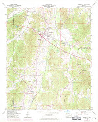
1950 Map of Burnsville
USGS Topo · Published 1971About this map
The railroad settlement of Burnsville serves as the focal point of this northeast Mississippi landscape, where the Southern and Illinois Central rail lines converge. The surrounding terrain in Tishomingo Co and Alcorn Co is defined by a sophisticated water management system, including the Yellow Creek Drainage Canal and Coke Drainage Canal, which were engineered to regulate the low-lying areas. This 1950s-era geography reflects a deeply rooted rural community, marked by numerous local landmarks such as Lambert Chapel School and Antioch Ch.
Find a feature on this map
50 named features on this map. Tap any name to fly to it.
Don’t see what you’re looking for? This feature index may not catch every label — zoom into the map to look around manually.
Map Details
Editions of this 1950 Burnsville Map
3 editions found
Other maps of this area

1911 · Iuka
USGS Topo · 1:48,000

1914 · Iuka
USGS Topo · 1:62,500

1935 · Holcut
USGS Topo · 1:24,000

1935 · Doskie
USGS Topo · 1:24,000

1935 · Iuka
USGS Topo · 1:24,000

1935 · Leedy
USGS Topo · 1:24,000

1935 · Glens
USGS Topo · 1:24,000

1936 · Kendrick
USGS Topo · 1:24,000

1936 · Shaws
USGS Topo · 1:24,000

1936 · Tishomingo
USGS Topo · 1:24,000