1980s Maps of Scott County, Mississippi
Explore 15 historic maps of Scott County from the 1980s. These maps offer a rare glimpse into what life looked like during the 1980s — showing old roads, neighborhoods, homes, and landmarks that have changed or disappeared over time.
Whether you're researching your family's past, planning a metal detecting trip, or studying how Scott County's landscape evolved across the 1980s, these high-resolution maps are a powerful tool for exploring the history of this region.
- Focus on a specific era: All maps on this page are from the 1980s, giving you a focused view of this time period.
- See what’s changed: Compare century-old streets, trails, and buildings to today's modern landscape using overlays and satellite layers.
- Research with precision: Use these maps for genealogy, historical research, land use analysis, or educational projects.
- View, download, or print: Maps are fully viewable online in high resolution, and can be downloaded or printed for your own records.
Start exploring Scott County's history through authentic maps from the 1980s. This is your window into the past.
Scott County, MS maps
(15)- 1982 Map of Forkville
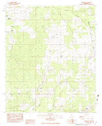
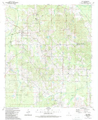
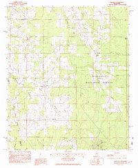 1982 Forkville1982 Print · USGSThe rural communities of Scott and Rankin Counties are shown here in the early 1980s, centered around Forkville and the Bienville National Forest. Genealogists can trace family roots through numerous sites like Latham Cem, Macedonia Ch, and the Indian Treaty Boundary.
 - 1982 Map of Harperville, 1983 Print
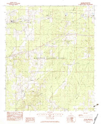
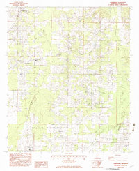 1982 Harperville1983 Print · USGSScott County in the early eighties reveals a landscape of tight-knit rural communities and forest lands. Genealogists can trace family footprints through sites like Singleton Settlement, Old Union Cem, and numerous country churches including Ephesus Ch.
 - 1982 Map of Conehatta, 1983 Print
 1982 Conehatta1983 Print · USGSThe Choctaw Indian Reservation and the rural communities of eastern Scott and Newton counties are captured here in the early eighties. Genealogists can trace family landmarks like Futch's Cem, Macedonia Ch, and Conehatta Sch.
 - 1982 Map of Morton, 1983 Print
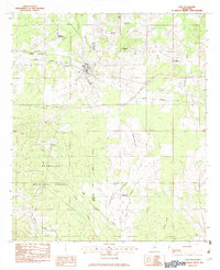
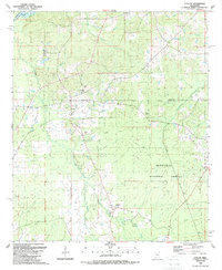
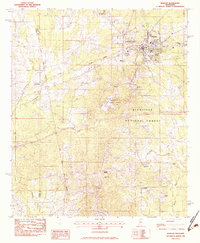 1982 Morton1983 Print · USGSThe town of Morton and its surrounding timberlands are captured in the early eighties, showing a community defined by its rail access and proximity to the national forest. Trace local roots through a wealth of rural landmarks like Kracker Station, Walker Cem, and the Indian Treaty Boundary.2 unique versions available
 - 1982 Map of Forest, 1983 Print
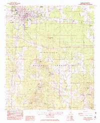 1982 Forest1983 Print · USGSThe northern reaches of the BIENVILLE NATIONAL FOREST meet the growing town of FOREST in the early 1980s. Genealogists can trace rural roots through numerous churches and cemeteries like Eastern Cem, High Hill Ch, and Gatewood Cem.2 unique versions available
 - 1982 Map of Hillsboro, 1983 Print
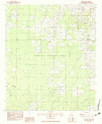 1982 Hillsboro1983 Print · USGSCentral Mississippi's timberlands and rural crossroads are captured here in the early eighties. Genealogists and historians can trace family sites at Old Duncan Cem or follow the Shockaloe Trail through Bienville National Forest.
 - 1982 Map of Lake, 1983 Print
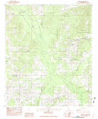
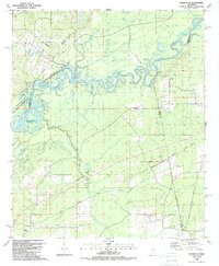
 1982 Lake1983 Print · USGSThe Scott and Newton county line comes alive in the 1980s as the railroad passes through Lake. Genealogists and historians can locate Dennis Settlement, the Patrons Union Campground, and small rail sites like Muskegon.
 - 1982 Map of Pulaski, 1983 Print
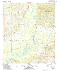
 1982 Pulaski1983 Print · USGSCentral Mississippi timberlands and small rail-side settlements define this landscape in the early eighties. Genealogists can trace family names through landmarks like North Morton Cem, Raworth, and Hunter Town near the Strong River.
 - 1982 Map of Leesburg, 1983 Print
 1982 Leesburg1983 Print · USGSThe rural communities of Rankin County were still deeply defined by their country churches and schools in the early eighties. Genealogists can locate family landmarks like Pisgah Cem, Oak Grove Ch, and the settlement at Leesburg.
 - 1984 Map of Forest
 1984 Forest1984 Print · USGSCentral Mississippi in the mid-eighties centers on the timberlands and rail corridors of the Bienville National Forest. Genealogists and historians can trace old settlements like Conehatta and Hillsboro or follow the Illinois Central Gulf line through Morton and Newton.2 unique versions available
 - 1984 Map of Carthage
 1984 Carthage1984 Print · USGSLeake and Neshoba counties in the mid-1980s showcase a transition from the Government Hills to the dense Bienville National Forest. Genealogists and researchers can trace the historic Natchez Trace Parkway and local settlements like Plattsburg and Williamsville.
 - 1988 Map of Sharon SE, 1989 Print
 1988 Sharon SE1989 Print · USGSThe borderlands of Madison, Rankin, and Scott Counties are captured in the late eighties as the Pearl River basin remained a mosaic of oxbow lakes and wetlands. Trace family roots at Sand Hill Ch, Lone Pine Ch, or Pisgah Cem while exploring the corridor of the Old Natzhez Trace Parkway.
 - 1989 Map of Ofahoma
 1989 Ofahoma1989 Print · USGSCentral Mississippi in the late eighties shows a landscape shaped by the Pearl River floodplains and the high Government Hills. Trace the paths of local life through the Natchez Trace Parkway or find family landmarks like Tribulation Ch and Good Hope.
 - 1989 Map of Ludlow
 1989 Ludlow1989 Print · USGSIn the late 1980s, the Mississippi timberlands near Ludlow remained a landscape of forest reserves and family burial grounds. Local historians can trace early transportation routes like the Old RR Grade or locate sites like Mt Zion Ch and Pearson Cem.
 - 1989 Map of Lena
 1989 Lena1989 Print · USGSCentral Mississippi in the late eighties shows a landscape shaped by timber history and rural faith. Genealogists and historians can trace family ties through Sweetwater Ch and Robinson Cem, or locate the timber-era tracks at Sproles Siding.
End of results
Showing maps 1-15 of 15
Top cities of Scott County
Frequently asked questions
- What are the different types of historical maps available for Scott County?
- What is the oldest map of Scott County?
- Where can I purchase historical maps of Scott County for my home or office?
- Where can I download high-res historical maps of Scott County?
- Are there historical topographic maps available for Scott County?
- Is there historical aerial imagery available for Scott County?
- Where are historical maps of Scott County sourced from?