1900s (20th Century) Maps of Scott County, Mississippi
Explore 38 historic maps of Scott County from the 1900s (20th Century). These maps offer a rare glimpse into what life looked like during the 1900s — showing old roads, neighborhoods, homes, and landmarks that have changed or disappeared over time.
Whether you're researching your family's past, planning a metal detecting trip, or studying how Scott County's landscape evolved across the 1900s, these high-resolution maps are a powerful tool for exploring the history of this region.
- Focus on a specific era: All maps on this page are from the 1900s, giving you a focused view of this time period.
- See what’s changed: Compare century-old streets, trails, and buildings to today's modern landscape using overlays and satellite layers.
- Research with precision: Use these maps for genealogy, historical research, land use analysis, or educational projects.
- View, download, or print: Maps are fully viewable online in high resolution, and can be downloaded or printed for your own records.
Start exploring Scott County's history through authentic maps from the 1900s. This is your window into the past.
Scott County, MS maps
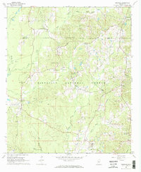
(38)- 1921 Map of Forest
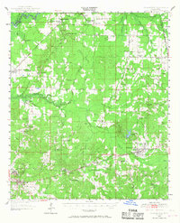
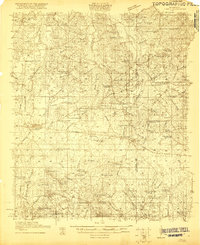 1921 Forest1921 Print · USGSThe Scott County landscape in the early 1920s is documented here through its rural schoolhouses and family settlements. Genealogists can locate long-standing community centers like the Patrons Union Camp Ground, Singleton Settlement, and Fikestown.
 - 1922 Map of Forest
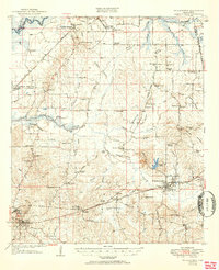
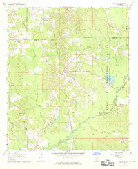
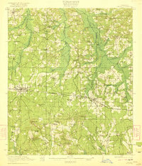 1922 Forest1922 Print · USGSScott and Newton Counties are shown here in the early twenties, when timber and rails defined the landscape. You can trace the path of the Alabama and Vicksburg RR, locate family landmarks like Many Roads Hill, and find old meeting grounds like the Patrons Union Campground.2 unique versions available
 - 1922 Map of Morton
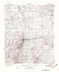
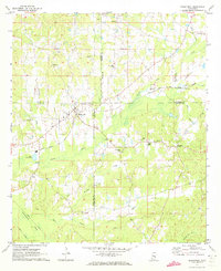
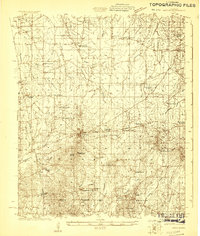 1922 Morton1922 Print · USGSScott County in the early twenties is a landscape of rural schoolhouses and timber operations centered on the Morton rail line. Researchers can locate vanished community landmarks like the Scott County Fair Grounds, Lumber Camp, and several family-named churches.
 - 1922 Map of Pelahatchee
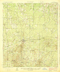
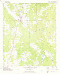
 1922 Pelahatchee1922 Print · USGSRankin County during the early 1920s reveals a landscape of dispersed agricultural communities and transit corridors. You can trace the roots of local settlements at Sand Hill and Leesburg, or locate family landmarks like Pisgah School and St Helen Church.
 - 1924 Map of Pelahatchee
 1924 Pelahatchee1924 Print · USGSRankin County in the 1920s is a landscape of rural schoolhouses and family-named prairies centered on the vital Alabama and Vicksburg RR. Researchers can trace the heritage of local communities through landmarks like the Brandon depot, Trickum Bridge, and Goshen Springs.
 - 1924 Map of Morton
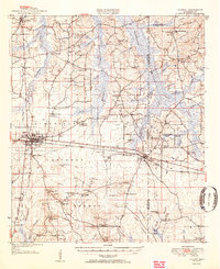
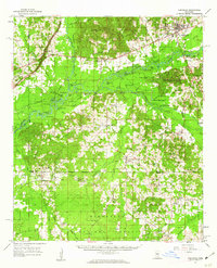
 1924 Morton1924 Print · USGSThe rail-and-timber landscape of Scott and Rankin counties is captured here in the early twenties. Researchers can trace rural life through dozens of named landmarks like Peagler Store, Morton, and the Sprous Cemetery.
 - 1950 Map of Forest, 1966 Print
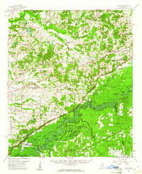
 1950 Forest1966 Print · USGSMid-century Scott County centers on the rail-driven growth of Forest and its surrounding timberlands. Local historians can trace family ties through Singleton Settlement, rural schools like Sylvester Sch, and the Patrons Union Campground.2 unique versions available
 - 1950 Map of Pelahatchie, 1968 Print
 1950 Pelahatchie1968 Print · USGSRankin County's rural landscape is captured here at mid-century, from the busy rails of Brandon to the quiet reaches of Goshen Springs. Researchers can trace old family names at Andrews Chapel, St Helens Ch, or the Spring Hill Cem while following the historic Choctaw Treaty Line of 1820.2 unique versions available
 - 1951 Map of Morton
 1951 Morton1951 Print · USGSMid-century Scott and Rankin counties are mapped here just as the modern highway system began to overshadow the rail era. Genealogists can locate family landmarks like Peagler Store and numerous rural sites such as Simmons Grove Ch and Latham Cem.3 unique versions available
 - 1952 Map of Pelahatchie
 1952 Pelahatchie1952 Print · USGSRankin County during the early 1950s shows a landscape still defined by its nineteenth-century boundaries and growing rail hubs. Genealogists and historians can trace family locations near Goshen Springs, the Choctaw Treaty Line of 1820, and Andrews Chapel.
 - 1952 Map of Forest
 1952 Forest1952 Print · USGSCentral Mississippi in the early fifties shows a landscape of rail-side growth and established family settlements. You can trace early Scott County history through rural landmarks like the Patrons Union Campground, Singleton Settlement, and Gum Springs.2 unique versions available
 - 1953 Map of Meridian, 1966 Print
 1953 Meridian1966 Print · USGSEast Central Mississippi and the Alabama borderlands are captured here during a period of steady growth and infrastructure expansion. Genealogists and historians can trace rail-town development along the Gulf Mobile & Ohio Railroad and find early settlements like Scooba, Pelahatchie, and De Kalb.2 unique versions available
 - 1957 Map of Meridian
 1957 Meridian1957 Print · USGSEast Central Mississippi and parts of Western Alabama come alive in the mid-1950s, centered on the transit hub of Meridian. Researchers can trace old rail lines like the Illinois Central and find historic sites such as the Choctaw Indian Reservation and Roosevelt State Park.
 - 1960 Map of Sharon, 1961 Print
 1960 Sharon1961 Print · USGSMadison County in the early sixties sits at a crossroads as the Pearl River Valley Reservoir begins to take shape. Genealogists and local historians can trace rural roots through landmarks like Zion Chapel Cem, the Sacred Heart Mission, and small hubs like Farmhaven.2 unique versions available
 - 1961 Map of Carthage, 1962 Print
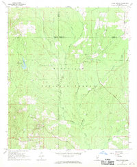
 1961 Carthage1962 Print · USGSLeake County and the central Mississippi timberlands are captured here in the early sixties, showing the area as the Bienville National Forest and local rail lines defined the economy. Genealogists can trace family roots through numerous sites like Tribulation Cem, Free Mission Ch, and Ofahoma.3 unique versions available
 - 1965 Map of Meridian
 1965 Meridian1965 Print · USGSEast Mississippi and West Alabama are mapped here in the mid-sixties as the region's modern highway and reservoir systems began to take shape. Researchers can trace rural lineages through local landmarks like Prince Chapel and Tuscahoma Landing, or follow the historic Gulf Mobile & Ohio rail lines.
 - 1968 Map of Clear Springs, 1970 Print
 1968 Clear Springs1970 Print · USGSCentral Mississippi's piney woods come alive in the late sixties, showing where the borders of four counties meet within the Bienville National Forest. Genealogists and historians can trace the rural communities around Clear Springs, Mt Calvary Ch, and the Burnett Cem.
 - 1968 Map of Pineville, 1970 Print
 1968 Pineville1970 Print · USGSThe Pineville area of Mississippi's Bienville National Forest is captured here in the late sixties as a landscape of timber and rural community. Researchers can trace the Old Railroad Grade or locate family landmarks like Noblin Cem, Mt Carmel Ch, and Oak Ridge Ch.2 unique versions available
 - 1968 Map of Homewood, 1970 Print
 1968 Homewood1970 Print · USGSIn the pine-heavy borderlands of Scott and Smith counties during the late sixties, rural life centered on small timber and mining outposts. Researchers can trace family history through sites like Burns Sch and Zion Cem or locate industrial Bentonite Pits near Lorena.2 unique versions available
 - 1968 Map of Polkville, 1970 Print
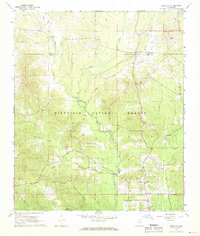
 1968 Polkville1970 Print · USGSCentral Mississippi's timber and farm country comes into focus in the late 1960s, centered on the community of Polkville. Researchers can trace early land divisions along the Old Indian Treaty Boundary and locate family landmarks like Haile Cem and Piney Grove Ch.3 unique versions available
 - 1972 Map of Sebastopol, 1973 Print
 1972 Sebastopol1973 Print · USGSThe intersection of four counties in central Mississippi comes alive in the early seventies, centered on the railroad town of Sebastopol. Genealogists and historians can trace the locations of rural landmarks like Steam Mill, Milldale Cem, and Hays.
 - 1972 Map of Walnut Grove, 1974 Print
 1972 Walnut Grove1974 Print · USGSThe rail and river geography of central Mississippi comes into focus in the early seventies, centered on the community of Walnut Grove. Local historians can trace the Gulf Mobile and Ohio rail line or locate family sites like Lindsey Cem and Damascus Ch.
 - 1982 Map of Forkville
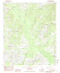
 1982 Forkville1982 Print · USGSThe rural communities of Scott and Rankin Counties are shown here in the early 1980s, centered around Forkville and the Bienville National Forest. Genealogists can trace family roots through numerous sites like Latham Cem, Macedonia Ch, and the Indian Treaty Boundary.
 - 1982 Map of Harperville, 1983 Print
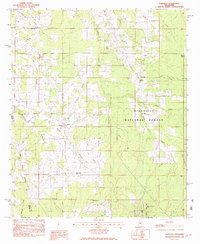
 1982 Harperville1983 Print · USGSScott County in the early eighties reveals a landscape of tight-knit rural communities and forest lands. Genealogists can trace family footprints through sites like Singleton Settlement, Old Union Cem, and numerous country churches including Ephesus Ch.
 - 1982 Map of Conehatta, 1983 Print
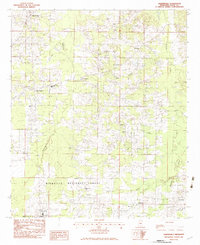
 1982 Conehatta1983 Print · USGSThe Choctaw Indian Reservation and the rural communities of eastern Scott and Newton counties are captured here in the early eighties. Genealogists can trace family landmarks like Futch's Cem, Macedonia Ch, and Conehatta Sch.
Showing maps 1-25 of 38
Top cities of Scott County
Frequently asked questions
- What are the different types of historical maps available for Scott County?
- What is the oldest map of Scott County?
- Where can I purchase historical maps of Scott County for my home or office?
- Where can I download high-res historical maps of Scott County?
- Are there historical topographic maps available for Scott County?
- Is there historical aerial imagery available for Scott County?
- Where are historical maps of Scott County sourced from?