1920s Maps of Scott County, Mississippi
Explore 6 historic maps of Scott County from the 1920s. These maps offer a rare glimpse into what life looked like during the 1920s — showing old roads, neighborhoods, homes, and landmarks that have changed or disappeared over time.
Whether you're researching your family's past, planning a metal detecting trip, or studying how Scott County's landscape evolved across the 1920s, these high-resolution maps are a powerful tool for exploring the history of this region.
- Focus on a specific era: All maps on this page are from the 1920s, giving you a focused view of this time period.
- See what’s changed: Compare century-old streets, trails, and buildings to today's modern landscape using overlays and satellite layers.
- Research with precision: Use these maps for genealogy, historical research, land use analysis, or educational projects.
- View, download, or print: Maps are fully viewable online in high resolution, and can be downloaded or printed for your own records.
Start exploring Scott County's history through authentic maps from the 1920s. This is your window into the past.
Scott County, MS maps
(6)- 1921 Map of Forest
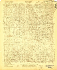 1921 Forest1921 Print · USGSThe Scott County landscape in the early 1920s is documented here through its rural schoolhouses and family settlements. Genealogists can locate long-standing community centers like the Patrons Union Camp Ground, Singleton Settlement, and Fikestown.
 - 1922 Map of Forest
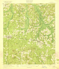 1922 Forest1922 Print · USGSScott and Newton Counties are shown here in the early twenties, when timber and rails defined the landscape. You can trace the path of the Alabama and Vicksburg RR, locate family landmarks like Many Roads Hill, and find old meeting grounds like the Patrons Union Campground.2 unique versions available
 - 1922 Map of Morton
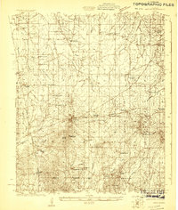 1922 Morton1922 Print · USGSScott County in the early twenties is a landscape of rural schoolhouses and timber operations centered on the Morton rail line. Researchers can locate vanished community landmarks like the Scott County Fair Grounds, Lumber Camp, and several family-named churches.
 - 1922 Map of Pelahatchee
 1922 Pelahatchee1922 Print · USGSRankin County during the early 1920s reveals a landscape of dispersed agricultural communities and transit corridors. You can trace the roots of local settlements at Sand Hill and Leesburg, or locate family landmarks like Pisgah School and St Helen Church.
 - 1924 Map of Pelahatchee
 1924 Pelahatchee1924 Print · USGSRankin County in the 1920s is a landscape of rural schoolhouses and family-named prairies centered on the vital Alabama and Vicksburg RR. Researchers can trace the heritage of local communities through landmarks like the Brandon depot, Trickum Bridge, and Goshen Springs.
 - 1924 Map of Morton
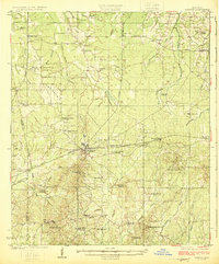 1924 Morton1924 Print · USGSThe rail-and-timber landscape of Scott and Rankin counties is captured here in the early twenties. Researchers can trace rural life through dozens of named landmarks like Peagler Store, Morton, and the Sprous Cemetery.
End of results
Showing maps 1-6 of 6
Top cities of Scott County
Frequently asked questions
- What are the different types of historical maps available for Scott County?
- What is the oldest map of Scott County?
- Where can I purchase historical maps of Scott County for my home or office?
- Where can I download high-res historical maps of Scott County?
- Are there historical topographic maps available for Scott County?
- Is there historical aerial imagery available for Scott County?
- Where are historical maps of Scott County sourced from?