1960s Maps of Sharkey County, Mississippi
Explore 11 historic maps of Sharkey County from the 1960s. These maps offer a rare glimpse into what life looked like during the 1960s — showing old roads, neighborhoods, homes, and landmarks that have changed or disappeared over time.
Whether you're researching your family's past, planning a metal detecting trip, or studying how Sharkey County's landscape evolved across the 1960s, these high-resolution maps are a powerful tool for exploring the history of this region.
- Focus on a specific era: All maps on this page are from the 1960s, giving you a focused view of this time period.
- See what’s changed: Compare century-old streets, trails, and buildings to today's modern landscape using overlays and satellite layers.
- Research with precision: Use these maps for genealogy, historical research, land use analysis, or educational projects.
- View, download, or print: Maps are fully viewable online in high resolution, and can be downloaded or printed for your own records.
Start exploring Sharkey County's history through authentic maps from the 1960s. This is your window into the past.
Sharkey County, MS maps
(11)- 1961 Map of Jackson
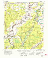
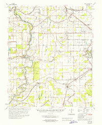
 1961 Jackson1961 Print · USGSThe Lower Mississippi Delta and the state capital area are captured here during the post-war era of infrastructure expansion. Researchers can trace the complex river oxbows and rail lines connecting Vicksburg, Yazoo City, and the Illinois Central Railroad network.
 - 1961 Map of Bayland
 1961 Bayland1961 Print · USGSThe Mississippi Delta's intricate water network and rural communities are captured here in the early sixties. Genealogists and historians can trace family locations through Huddleston Cem, Indian Mounds, and the Humphreys Co Training School.3 unique versions available
 - 1962 Map of Jackson
 1962 Jackson1962 Print · USGSThe Mississippi Delta and the state capital region are mapped here in the early sixties, showing a landscape defined by the great river and the growing city of JACKSON. Genealogists can trace family roots through numerous landmarks like Cedar Hill Cem, rural stops on the Illinois Central RR, and historic sites like Champion Hill.2 unique versions available
 - 1963 Map of Mechanicsburg, 1965 Print
 1963 Mechanicsburg1965 Print · USGSThe Yazoo Delta and its surrounding bluffs are shown in the early sixties as a landscape of river landings and rural parishes. Researchers can trace family history through Satartia, Mechanicsburg, and numerous rural churches like Germania El Bethel Ch or Lynch Chapel.
 - 1963 Map of Onward, 1965 Print
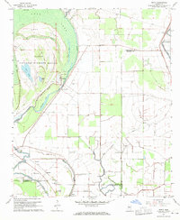
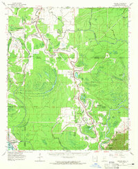 1963 Onward1965 Print · USGSThe Mississippi Delta lowlands appear in detail in the early sixties, showing the rail-and-river network before modern land-use changes. Genealogists can trace family names through rural landmarks like Rock of Mt Zion Ch, Valley Park, and the Cement Plant at Haynes Bluff.3 unique versions available
 - 1964 Map of Lorenzen, 1966 Print
 1964 Lorenzen1966 Print · USGSThe Mississippi Delta's intricate bayou network is meticulously detailed here during the mid-1960s. Genealogists and local historians can trace family roots through numerous landmarks like St Michaels Ch, Elmwood Cem, and the old rail stop at Riverside Junction.2 unique versions available
 - 1965 Map of Richey, 1966 Print
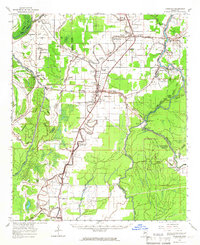
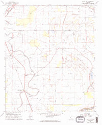
 1965 Richey1966 Print · USGSSharkey County and the surrounding Delta lands are captured here in the mid-1960s as the river economy remained central to local life. Genealogists can locate family landmarks like Short Jerusalem Ch and the river crossings at Murphy Ferry or Bommers Ferry.
 - 1967 Map of Auter
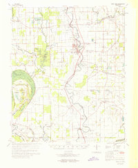
 1967 Auter1967 Print · USGSHumphreys County and the surrounding Delta flatlands are captured here in the late sixties as the agricultural economy relied on both rail and river. Trace family roots at Midnight or Silver City, and find old landmarks like River Oak Sch and Pilgrim Rest Cem.
 - 1967 Map of Percy, 1970 Print
 1967 Percy1970 Print · USGSThis Mississippi Delta landscape in the late sixties reveals a mix of protected wetlands and deep-rooted agricultural life across three counties. Genealogists and researchers can locate old communities like Percy and Grace, or trace family landmarks including Canaan Hill Cem and Goodwill Ch.2 unique versions available
 - 1968 Map of Delta City, 1970 Print
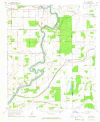
 1968 Delta City1970 Print · USGSThe Mississippi Delta's agricultural landscape is captured here in the late sixties as rail and river networks defined local life. Trace family roots and vanished landmarks near Delta City, Nitta Yuma, and several Indian Mounds along the Illinois Central.2 unique versions available
 - 1969 Map of Swan Lake
 1969 Swan Lake1969 Print · USGSThe Mississippi Delta in the late sixties reveals a landscape of productive cotton fields and vital wetlands along Deer Creek. Genealogists can trace family names at Bellamy Cem, visit Simmons Sch, or locate the historic siding at Panther Burn.
End of results
Showing maps 1-11 of 11
Top cities of Sharkey County
Frequently asked questions
- What are the different types of historical maps available for Sharkey County?
- What is the oldest map of Sharkey County?
- Where can I purchase historical maps of Sharkey County for my home or office?
- Where can I download high-res historical maps of Sharkey County?
- Are there historical topographic maps available for Sharkey County?
- Is there historical aerial imagery available for Sharkey County?
- Where are historical maps of Sharkey County sourced from?