1980s Maps of Charleston, Mississippi
Explore 4 historic maps of Charleston from the 1980s. These maps offer a rare glimpse into what life looked like during the 1980s — showing old roads, neighborhoods, homes, and landmarks that have changed or disappeared over time.
Whether you're researching your family's past, planning a metal detecting trip, or studying how Charleston's landscape evolved across the 1980s, these high-resolution maps are a powerful tool for exploring the history of this region.
- Focus on a specific era: All maps on this page are from the 1980s, giving you a focused view of this time period.
- See what’s changed: Compare century-old streets, trails, and buildings to today's modern landscape using overlays and satellite layers.
- Research with precision: Use these maps for genealogy, historical research, land use analysis, or educational projects.
- View, download, or print: Maps are fully viewable online in high resolution, and can be downloaded or printed for your own records.
Start exploring Charleston's history through authentic maps from the 1980s. This is your window into the past.
Charleston, MS maps
(4)- 1981 Map of Paynes, 1982 Print
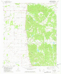 1981 Paynes1982 Print · USGSIn the early eighties, this pocket of Tallahatchie County shows the rural transition from the flatlands to the hill country. Genealogists can locate family landmarks like Magnolia Cem and Adams Arbor Ch or trace the winding course of Ascalmore Creek.
 - 1982 Map of Charleston, 1983 Print
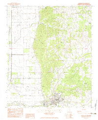 1982 Charleston1983 Print · USGSThe Tallahatchie County hills meet the delta plains in the early eighties, centered on the civic life of Charleston. Researchers can trace the rural infrastructure of the era through sites like Teasdale, Mt Zion Ch, and New Town Cem.
 - 1983 Map of Greenwood
 1983 Greenwood1983 Print · USGSThe Mississippi Delta in the early eighties shows a landscape of rail-connected towns and vast river systems. Genealogists and historians can trace family roots in towns like Mound Bayou, Ruleville, and the grounds of Mississippi Valley State University.
 - 1984 Map of Clarksdale, 1985 Print
 1984 Clarksdale1985 Print · USGSThe Mississippi Delta in the 1980s shows a landscape defined by its great river meanders and a dense network of bayous and rail lines. Researchers can trace the path of the Illinois Central Gulf through Clarksdale or locate river landmarks like Moon Lake and Friars Point.
End of results
Showing maps 1-4 of 4
Top cities near Charleston
Frequently asked questions
- What are the different types of historical maps available for Charleston?
- What is the oldest map of Charleston?
- Where can I purchase historical maps of Charleston for my home or office?
- Where can I download high-res historical maps of Charleston?
- Are there historical topographic maps available for Charleston?
- Is there historical aerial imagery available for Charleston?
- Where are historical maps of Charleston sourced from?