1980s Maps of Warren County, Mississippi
Explore 8 historic maps of Warren County from the 1980s. These maps offer a rare glimpse into what life looked like during the 1980s — showing old roads, neighborhoods, homes, and landmarks that have changed or disappeared over time.
Whether you're researching your family's past, planning a metal detecting trip, or studying how Warren County's landscape evolved across the 1980s, these high-resolution maps are a powerful tool for exploring the history of this region.
- Focus on a specific era: All maps on this page are from the 1980s, giving you a focused view of this time period.
- See what’s changed: Compare century-old streets, trails, and buildings to today's modern landscape using overlays and satellite layers.
- Research with precision: Use these maps for genealogy, historical research, land use analysis, or educational projects.
- View, download, or print: Maps are fully viewable online in high resolution, and can be downloaded or printed for your own records.
Start exploring Warren County's history through authentic maps from the 1980s. This is your window into the past.
Warren County, MS maps
(8)- 1982 Map of Tallulah, 1983 Print
 1982 Tallulah1983 Print · USGSNortheast Louisiana in the early eighties was a landscape of intricate oxbow lakes and railroad towns. Researchers can trace the heritage of parish centers like Tallulah and Winnsboro, or locate rural landmarks near Yucatan Lake and the Illinois Central Gulf tracks.
 - 1982 Map of Bastrop, 1983 Print
 1982 Bastrop1983 Print · USGSNortheastern Louisiana and the Mississippi River Delta are captured here in the early eighties as a landscape of bayous and river towns. Genealogists and historians can trace small communities like Mer Rouge and Oak Grove or the ancient terrain of Poverty Point State Park.
 - 1984 Map of Yazoo City
 1984 Yazoo City1984 Print · USGSThe Mississippi Delta and loess bluffs meet in the mid-eighties as the Yazoo River snakes through a dense network of wildlife areas and rail lines. Researchers can trace rural life and drainage history through small communities like Holly Bluff, Mechanicsburg, and Satartia.2 unique versions available
 - 1984 Map of Jackson
 1984 Jackson1984 Print · USGSCentral Mississippi in the mid-eighties shows a landscape defined by the growing suburbs of Jackson and the riverfront legacy of Vicksburg. Researchers can trace the Natchez Trace Parkway or locate local landmarks like Utica College and Mississippi State Hospital.
 - 1988 Map of Floweree
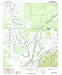 1988 Floweree1988 Print · USGSThe alluvial plains of Warren County are captured here in the late eighties, showing a landscape defined by the Yazoo River. Researchers can trace the Old Indian Treaty Boundary and locate early settlements like Floweree, Hardee, and Katzenmeyer.
 - 1988 Map of Cane Bayou
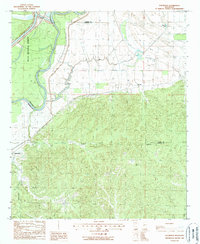
 1988 Cane Bayou1988 Print · USGSIssaquena and Warren counties are captured in the late 1980s as a complex network of bayous and oxbow lakes. Genealogists and historians can trace property lines against the Old Indian Treaty Bdy and the banks of Eagle Lake or Cypress Lake.
 - 1988 Map of Phoenix
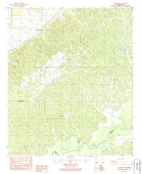 1988 Phoenix1988 Print · USGSThe hill country of Yazoo County in the late eighties is documented here as it reaches down toward the Big Black River. Researchers can locate several rural Cem sites and trace the ridges connecting the settlements of Phoenix and Germania.
 - 1988 Map of Eldorado
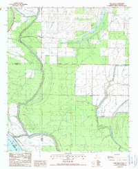
 1988 Eldorado1988 Print · USGSWarren and Yazoo Counties in the late 1980s show a landscape of river-bend wetlands and wooded uplands. Genealogists and historians can trace the positions of Eldorado and Russellville, or follow the path of the Old RR Grade and Corn House Creek.
End of results
Showing maps 1-8 of 8
Top cities of Warren County
Frequently asked questions
- What are the different types of historical maps available for Warren County?
- What is the oldest map of Warren County?
- Where can I purchase historical maps of Warren County for my home or office?
- Where can I download high-res historical maps of Warren County?
- Are there historical topographic maps available for Warren County?
- Is there historical aerial imagery available for Warren County?
- Where are historical maps of Warren County sourced from?