1970s Maps of Warren County, Mississippi
Explore 5 historic maps of Warren County from the 1970s. These maps offer a rare glimpse into what life looked like during the 1970s — showing old roads, neighborhoods, homes, and landmarks that have changed or disappeared over time.
Whether you're researching your family's past, planning a metal detecting trip, or studying how Warren County's landscape evolved across the 1970s, these high-resolution maps are a powerful tool for exploring the history of this region.
- Focus on a specific era: All maps on this page are from the 1970s, giving you a focused view of this time period.
- See what’s changed: Compare century-old streets, trails, and buildings to today's modern landscape using overlays and satellite layers.
- Research with precision: Use these maps for genealogy, historical research, land use analysis, or educational projects.
- View, download, or print: Maps are fully viewable online in high resolution, and can be downloaded or printed for your own records.
Start exploring Warren County's history through authentic maps from the 1970s. This is your window into the past.
Warren County, MS maps
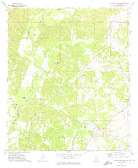
(5)- 1970 Map of Eagle Bend, 1972 Print
 1970 Eagle Bend1972 Print · USGSThe Mississippi Delta's shifting riverbanks and oxbow lakes are captured in the early 1970s as the state line weaves between parishes. Genealogists and local historians can trace rural landmarks like Mt Olive Ch, Brunswick Cem, and the river landing at Eagle Bend.2 unique versions available
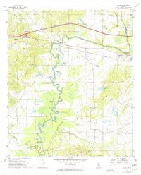
 - 1972 Map of Queens Hill Lake, 1974 Print
 1972 Queens Hill Lake1974 Print · USGSHinds and Warren counties meet along the meandering Big Black River in the early seventies, a landscape of deep hollows and rural outposts. Genealogists and local historians can trace family sites at Birdsong Cem, Henry-Grant Cem, and the old Rose Hill Ch.2 unique versions available
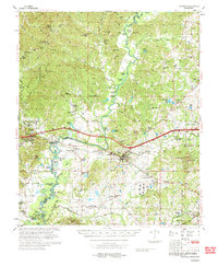
 - 1972 Map of Bovina, 1974 Print
 1972 Bovina1974 Print · USGSWarren and Hinds Counties are captured in the early seventies as the river-and-rail economy shaped the rural landscape. Genealogists can trace family landmarks like Montgomery Cem and several country churches including Morning Star Ch and Mt Hebron Ch.3 unique versions available
 - 1972 Map of Oak Ridge, 1974 Print
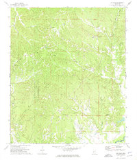 1972 Oak Ridge1974 Print · USGSWarren County ridge country is captured here in the early 1970s, showcasing a network of upland settlements and family burial grounds. Researchers can trace local lineage through sites like Hackler Cem, Brickhouse Cem, and Holy Hill Ch.2 unique versions available
 - 1975 Map of Edwards, 1976 Print
 1975 Edwards1976 Print · USGSCentral Mississippi in the mid-seventies shows a landscape of river-bottom farms and rail towns along the Illinois Central Gulf. Genealogists can trace family names through landmarks like Neely Cem, Taylor Cem, and the site of Mt Beulah College.
End of results
Showing maps 1-5 of 5
Top cities of Warren County
Frequently asked questions
- What are the different types of historical maps available for Warren County?
- What is the oldest map of Warren County?
- Where can I purchase historical maps of Warren County for my home or office?
- Where can I download high-res historical maps of Warren County?
- Are there historical topographic maps available for Warren County?
- Is there historical aerial imagery available for Warren County?
- Where are historical maps of Warren County sourced from?