1910s Maps of Warren County, Mississippi
Explore 2 historic maps of Warren County from the 1910s. These maps offer a rare glimpse into what life looked like during the 1910s — showing old roads, neighborhoods, homes, and landmarks that have changed or disappeared over time.
Whether you're researching your family's past, planning a metal detecting trip, or studying how Warren County's landscape evolved across the 1910s, these high-resolution maps are a powerful tool for exploring the history of this region.
- Focus on a specific era: All maps on this page are from the 1910s, giving you a focused view of this time period.
- See what’s changed: Compare century-old streets, trails, and buildings to today's modern landscape using overlays and satellite layers.
- Research with precision: Use these maps for genealogy, historical research, land use analysis, or educational projects.
- View, download, or print: Maps are fully viewable online in high resolution, and can be downloaded or printed for your own records.
Start exploring Warren County's history through authentic maps from the 1910s. This is your window into the past.
Warren County, MS maps
(2)- 1910 Map of Mound
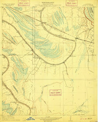 1910 Mound1910 Print · USGSMadison Parish in the early 1900s shows a landscape of productive riverbottom plantations and railroad commerce. Genealogists can trace family holdings and rural landmarks like California Plantation, Thomastown, and the Indian Mounds near the local rail siding.2 unique versions available
 - 1918 Map of Vicksburg
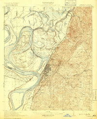 1918 Vicksburg1918 Print · USGSVicksburg and the Mississippi River bluffs are shown in great detail during the early twentieth century. Researchers can locate Civil War landmarks like Grants Canal and Vicksburg National Military Park or trace family roots near Blakeley and Cedars.4 unique versions available
End of results
Showing maps 1-2 of 2
Top cities of Warren County
Frequently asked questions
- What are the different types of historical maps available for Warren County?
- What is the oldest map of Warren County?
- Where can I purchase historical maps of Warren County for my home or office?
- Where can I download high-res historical maps of Warren County?
- Are there historical topographic maps available for Warren County?
- Is there historical aerial imagery available for Warren County?
- Where are historical maps of Warren County sourced from?