1960s Maps of Winston County, Mississippi
Explore 7 historic maps of Winston County from the 1960s. These maps offer a rare glimpse into what life looked like during the 1960s — showing old roads, neighborhoods, homes, and landmarks that have changed or disappeared over time.
Whether you're researching your family's past, planning a metal detecting trip, or studying how Winston County's landscape evolved across the 1960s, these high-resolution maps are a powerful tool for exploring the history of this region.
- Focus on a specific era: All maps on this page are from the 1960s, giving you a focused view of this time period.
- See what’s changed: Compare century-old streets, trails, and buildings to today's modern landscape using overlays and satellite layers.
- Research with precision: Use these maps for genealogy, historical research, land use analysis, or educational projects.
- View, download, or print: Maps are fully viewable online in high resolution, and can be downloaded or printed for your own records.
Start exploring Winston County's history through authentic maps from the 1960s. This is your window into the past.
Winston County, MS maps
(7)- 1962 Map of Vernon, 1963 Print
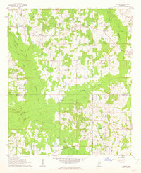 1962 Vernon1963 Print · USGSWinston and Neshoba Counties are captured in the early sixties, centered on rural communities and the significant Nanih Waiya Indian Mound. Researchers can trace local lineage through sites like Fulton Cem, Enon Ch, and Claytown.3 unique versions available
 - 1962 Map of Preston, 1963 Print
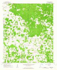 1962 Preston1963 Print · USGSThe tri-county borderlands of Winston, Noxubee, and Kemper counties are captured here in the early 1960s. Genealogists can locate family landmarks like Good Hope Ch, Hailey Cem, and the old schoolhouse at Preston.2 unique versions available
 - 1962 Map of Edinburg, 1964 Print
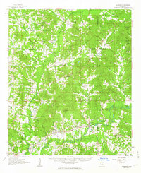 1962 Edinburg1964 Print · USGSCentral Mississippi's rural river country comes to life in the early sixties, showing the intersection of four counties along the Pearl River. Genealogists can trace family roots through numerous sites like Battleground Cemetery, Coughlin Mound, and the settlement at Edinburg.
 - 1963 Map of West Point
 1963 West Point1963 Print · USGSEastern Mississippi and western Alabama are captured in the early sixties as industrial centers and rail lines connected the Black Prairie to the hills. Genealogists and historians can trace family-named watercourses and the early footprints of Starkville, Columbus, and the Noxubee National Wildlife Refuge.2 unique versions available
 - 1965 Map of Meridian
 1965 Meridian1965 Print · USGSEast Mississippi and West Alabama are mapped here in the mid-sixties as the region's modern highway and reservoir systems began to take shape. Researchers can trace rural lineages through local landmarks like Prince Chapel and Tuscahoma Landing, or follow the historic Gulf Mobile & Ohio rail lines.
 - 1965 Map of Bluff Lake, 1966 Print
 1965 Bluff Lake1966 Print · USGSThe Oktibbeha County wetlands come into focus in the mid-sixties as conservation efforts shaped the local landscape. Genealogists and researchers can trace family landmarks like Bethel Ch and Noxubee Cem alongside the managed waters of Bluff Lake.
 - 1965 Map of Bradley, 1966 Print
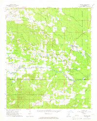 1965 Bradley1966 Print · USGSOktibbeha and Winston Counties are shown in the mid-1960s, a time when the rural landscape was defined by the Noxubee River and the Illinois Central railroad. Researchers can locate family landmarks like Pughs Mill Ch, McClelland Cem, and the old settlement of Bradley.3 unique versions available
End of results
Showing maps 1-7 of 7
Top cities of Winston County
Frequently asked questions
- What are the different types of historical maps available for Winston County?
- What is the oldest map of Winston County?
- Where can I purchase historical maps of Winston County for my home or office?
- Where can I download high-res historical maps of Winston County?
- Are there historical topographic maps available for Winston County?
- Is there historical aerial imagery available for Winston County?
- Where are historical maps of Winston County sourced from?