1970s Maps of Winston County, Mississippi
Explore 12 historic maps of Winston County from the 1970s. These maps offer a rare glimpse into what life looked like during the 1970s — showing old roads, neighborhoods, homes, and landmarks that have changed or disappeared over time.
Whether you're researching your family's past, planning a metal detecting trip, or studying how Winston County's landscape evolved across the 1970s, these high-resolution maps are a powerful tool for exploring the history of this region.
- Focus on a specific era: All maps on this page are from the 1970s, giving you a focused view of this time period.
- See what’s changed: Compare century-old streets, trails, and buildings to today's modern landscape using overlays and satellite layers.
- Research with precision: Use these maps for genealogy, historical research, land use analysis, or educational projects.
- View, download, or print: Maps are fully viewable online in high resolution, and can be downloaded or printed for your own records.
Start exploring Winston County's history through authentic maps from the 1970s. This is your window into the past.
Winston County, MS maps
(12)- 1972 Map of Louisville North, 1973 Print
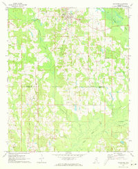
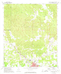 1972 Louisville North1973 Print · USGSWinston County in the early 1970s shows a landscape balancing the Tombigbee National Forest with the industrial growth of Louisville. Trace family history at Noxubee Hill Cem or locate rural landmarks like Poplar Flat Ch and the McMillan settlement.2 unique versions available
 - 1972 Map of Highpoint, 1973 Print
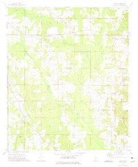
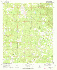 1972 Highpoint1973 Print · USGSThe Choctaw and Winston county line in the early seventies shows a rural landscape of timberland and small parishes. Genealogists can trace several family burial sites and country churches including Old Concord Cem, Mt Nebo Ch, and Turner Cem.2 unique versions available
 - 1972 Map of Plattsburg, 1973 Print
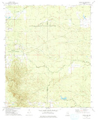
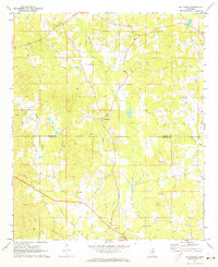 1972 Plattsburg1973 Print · USGSThe Winston and Neshoba county line divides this Mississippi landscape in the early seventies, a region of family farms and creek bottoms. Genealogists can trace local heritage through numerous landmarks like Indian Spring Ch, Lee Cem, and Plattsburg.
 - 1972 Map of Ethel SE, 1973 Print
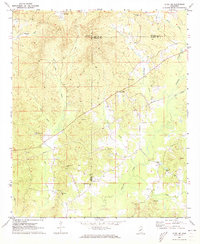 1972 Ethel SE1973 Print · USGSWinston and Attala counties meet in this early 1970s survey, showing a landscape of timbered ridges and rural crossroads. Researchers can trace family history through a high density of local landmarks like Edgefield Ch, Rural Hill, and the McCool Lookout Tower.
 - 1972 Map of Noxapater, 1973 Print
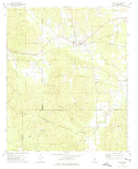
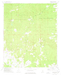
 1972 Noxapater1973 Print · USGSWinston County's timber and rail landscape is well-preserved here in the early seventies, centered on the town of Noxapater. Genealogists and historians can trace local landmarks like Stallo, the Gulf Mobile and Ohio railroad, and country churches like Salem Ch.
 - 1972 Map of Louisville South, 1973 Print
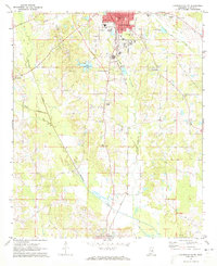 1972 Louisville South1973 Print · USGSWinston County enters the 1970s as a landscape of established rail towns and rural church communities. Genealogists and local historians can trace family sites at Macedonia Cem and Johnson Cem, or locate landmarks like the Drive-in Theater and Eates.2 unique versions available
 - 1972 Map of Louisville SW, 1973 Print
 1972 Louisville SW1973 Print · USGSThe Winston and Choctaw county line in the early 1970s reveals a landscape defined by its rural churches and small-scale creek-side operations. You can locate family history sites like Whitehall Ch, Ford Community Center, and the Steed Cem along the Noxapater Creek drainage.2 unique versions available
 - 1972 Map of Sturgis, 1975 Print
 1972 Sturgis1975 Print · USGSThe town of Sturgis and its surrounding timberlands are captured here in the early seventies as the railroad still connected the local economy. Genealogists can trace family names through landmarks like Old Sturgis Cem, Boyd Chapel, and the Tombigbee Lookout Tower.
 - 1973 Map of Boon, 1975 Print
 1973 Boon1975 Print · USGSWinston County settlements and community churches are documented here in the early seventies, just after the photogrammetric surveys of the previous year. Researchers can trace the rural hubs of Boon and Cork, alongside numerous landmarks like Zion Chapel and the Claypit.2 unique versions available
 - 1973 Map of Fearns Springs, 1975 Print
 1973 Fearns Springs1975 Print · USGSWinston and Noxubee counties appear here in the early 1970s, a rural landscape defined by family settlements and an Old Railroad Grade. Genealogists can trace deep local roots at Hemphill Cem, Fearns Springs, and Little Member Ch.
 - 1973 Map of Barge Lake, 1975 Print
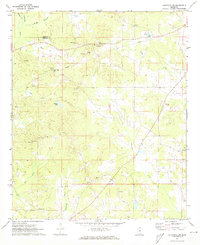
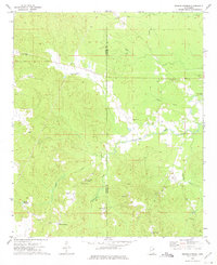
 1973 Barge Lake1975 Print · USGSWinston and Noxubee Counties are shown in the early seventies, a landscape defined by the wetlands of the Noxubee National Wildlife Refuge. Genealogists can locate family landmarks like Beth Cem, Conn Cem, and Antioch Ch.2 unique versions available
 - 1973 Map of Betheden, 1975 Print
 1973 Betheden1975 Print · USGSWinston County was a landscape of deep national forests and quiet rural hamlets during the early seventies. Genealogists can trace family roots through numerous country churches like Antioch Ch and cemeteries including Glenn Cem and Webster Cem.
End of results
Showing maps 1-12 of 12
Top cities of Winston County
Frequently asked questions
- What are the different types of historical maps available for Winston County?
- What is the oldest map of Winston County?
- Where can I purchase historical maps of Winston County for my home or office?
- Where can I download high-res historical maps of Winston County?
- Are there historical topographic maps available for Winston County?
- Is there historical aerial imagery available for Winston County?
- Where are historical maps of Winston County sourced from?