1970s Maps of Louisville, Mississippi
Explore 2 historic maps of Louisville from the 1970s. These maps offer a rare glimpse into what life looked like during the 1970s — showing old roads, neighborhoods, homes, and landmarks that have changed or disappeared over time.
Whether you're researching your family's past, planning a metal detecting trip, or studying how Louisville's landscape evolved across the 1970s, these high-resolution maps are a powerful tool for exploring the history of this region.
- Focus on a specific era: All maps on this page are from the 1970s, giving you a focused view of this time period.
- See what’s changed: Compare century-old streets, trails, and buildings to today's modern landscape using overlays and satellite layers.
- Research with precision: Use these maps for genealogy, historical research, land use analysis, or educational projects.
- View, download, or print: Maps are fully viewable online in high resolution, and can be downloaded or printed for your own records.
Start exploring Louisville's history through authentic maps from the 1970s. This is your window into the past.
Louisville, MS maps
(2)- 1972 Map of Louisville North, 1973 Print
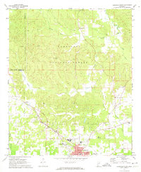 1972 Louisville North1973 Print · USGSWinston County in the early 1970s shows a landscape balancing the Tombigbee National Forest with the industrial growth of Louisville. Trace family history at Noxubee Hill Cem or locate rural landmarks like Poplar Flat Ch and the McMillan settlement.2 unique versions available
 - 1972 Map of Louisville South, 1973 Print
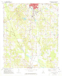 1972 Louisville South1973 Print · USGSWinston County enters the 1970s as a landscape of established rail towns and rural church communities. Genealogists and local historians can trace family sites at Macedonia Cem and Johnson Cem, or locate landmarks like the Drive-in Theater and Eates.2 unique versions available
End of results
Showing maps 1-2 of 2
Top cities near Louisville
Frequently asked questions
- What are the different types of historical maps available for Louisville?
- What is the oldest map of Louisville?
- Where can I purchase historical maps of Louisville for my home or office?
- Where can I download high-res historical maps of Louisville?
- Are there historical topographic maps available for Louisville?
- Is there historical aerial imagery available for Louisville?
- Where are historical maps of Louisville sourced from?