1970s Maps of Adair County, Missouri
Explore 11 historic maps of Adair County from the 1970s. These maps offer a rare glimpse into what life looked like during the 1970s — showing old roads, neighborhoods, homes, and landmarks that have changed or disappeared over time.
Whether you're researching your family's past, planning a metal detecting trip, or studying how Adair County's landscape evolved across the 1970s, these high-resolution maps are a powerful tool for exploring the history of this region.
- Focus on a specific era: All maps on this page are from the 1970s, giving you a focused view of this time period.
- See what’s changed: Compare century-old streets, trails, and buildings to today's modern landscape using overlays and satellite layers.
- Research with precision: Use these maps for genealogy, historical research, land use analysis, or educational projects.
- View, download, or print: Maps are fully viewable online in high resolution, and can be downloaded or printed for your own records.
Start exploring Adair County's history through authentic maps from the 1970s. This is your window into the past.
Adair County, MO maps
(11)- 1974 Map of Kirksville NE, 1976 Print
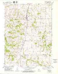
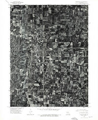 1974 Kirksville NE1976 Print · USGSMissouri's college town of Kirksville is shown in detail during the mid-seventies in this rectified aerial survey. Local historians can trace the exact footprint of residential expansion and agricultural land use as it appeared over forty years ago.
 - 1974 Map of Green City SE, 1976 Print
 1974 Green City SE1976 Print · USGSCovers Adair County, including Sidney, Greencastle, and other nearby areas
 - 1974 Map of Queen City SE, 1976 Print
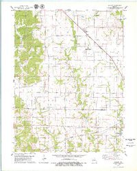
 1974 Queen City SE1976 Print · USGSAdair County farmsteads and rural crossroads are captured in this mid-seventies aerial survey of northern Missouri. Genealogists and local historians can trace property lines and the early footprint of Route 63 through settlements like Greentop and Sublette.
 - 1974 Map of Kirksville NW, 1976 Print
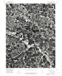
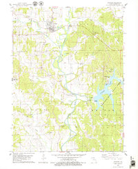
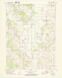
 1974 Kirksville NW1976 Print · USGSAdair County farmsteads and river bottoms are captured from the air in the mid-1970s, showing the landscape just as Forest Lake was becoming a local fixture. Trace the exact layout of Novinger and Youngstown along the winding Chariton River.
 - 1979 Map of Novinger
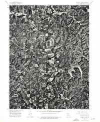
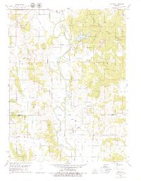
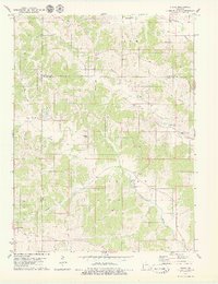
 1979 Novinger1979 Print · USGSThe Chariton River valley in the late 1970s shows a landscape of coal mining history and modern recreation. Researchers can trace family roots through Novinger Cem and Mt Moriah Cem or follow the path of the Old Railroad Grade through Danforth.
 - 1979 Map of Millard
 1979 Millard1979 Print · USGSThe borderlands of Adair and Macon counties are captured here in the late seventies, showing a landscape shaped by the Little Chariton River and major rail lines. Researchers can trace family history through sites like Shoemaker Cem or the rural settlement of Millard.
 - 1979 Map of Gifford
 1979 Gifford1979 Print · USGSAdair and Macon Counties in the late seventies show a landscape shaped by coal extraction and the winding Chariton River. Genealogists and historians can locate rural landmarks like Indian Hill Cem, the settlement of Yarrow, and several Strip Mines.2 unique versions available
 - 1979 Map of Greentop
 1979 Greentop1979 Print · USGSThe border of Schuyler and Adair counties is captured here in the late 1970s as agricultural life centered on the Norfolk and Western rail line. Genealogists and local historians can trace rural landmarks like Hazel Creek Ch, Sublette, and Oak Grove Cem.
 - 1979 Map of Kirksville
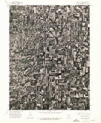
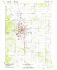 1979 Kirksville1979 Print · USGSKirksville serves as a major regional center in the late seventies, dominated by its university campuses and railroad junctions. Researchers can locate specific local landmarks like Northeast Mo State University, Maple Hill Cem, and Thousand Hills State Park.2 unique versions available
 - 1979 Map of Connelsville
 1979 Connelsville1979 Print · USGSAdair County during the late 1970s shows a landscape of river-bottom farms and small rural settlements centered on the Chariton River. Genealogists can trace family history through numerous remote burial sites like Nineveh Cem and Mulberry Cem or locate the Old Railroad Grade near Connelsville.
 - 1979 Map of Stahl
 1979 Stahl1979 Print · USGSAdair and Putnam Counties appear in the late seventies as a landscape of rural townships and family homesteads. Genealogists and historians can trace the Old Railroad Grade or locate numerous burial sites like Branstutter Cem and Shibleys Point Cem.
End of results
Showing maps 1-11 of 11
Top cities of Adair County
- Kirksville historical maps
- Novinger historical maps
- Brashear historical maps
- Gibbs historical maps
- Millard historical maps
Frequently asked questions
- What are the different types of historical maps available for Adair County?
- What is the oldest map of Adair County?
- Where can I purchase historical maps of Adair County for my home or office?
- Where can I download high-res historical maps of Adair County?
- Are there historical topographic maps available for Adair County?
- Is there historical aerial imagery available for Adair County?
- Where are historical maps of Adair County sourced from?