1970s Maps of Audrain County, Missouri
Explore 13 historic maps of Audrain County from the 1970s. These maps offer a rare glimpse into what life looked like during the 1970s — showing old roads, neighborhoods, homes, and landmarks that have changed or disappeared over time.
Whether you're researching your family's past, planning a metal detecting trip, or studying how Audrain County's landscape evolved across the 1970s, these high-resolution maps are a powerful tool for exploring the history of this region.
- Focus on a specific era: All maps on this page are from the 1970s, giving you a focused view of this time period.
- See what’s changed: Compare century-old streets, trails, and buildings to today's modern landscape using overlays and satellite layers.
- Research with precision: Use these maps for genealogy, historical research, land use analysis, or educational projects.
- View, download, or print: Maps are fully viewable online in high resolution, and can be downloaded or printed for your own records.
Start exploring Audrain County's history through authentic maps from the 1970s. This is your window into the past.
Audrain County, MO maps
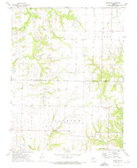
(13)- 1972 Map of Mexico East
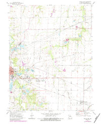 1972 Mexico East1972 Print · USGSThe eastern outskirts of Mexico, Missouri, are documented here in the early 1970s as the area balanced its agricultural roots with industrial and aviation growth. Genealogists and historians can trace the Missouri Military Academy, the village of Benton City, and numerous old Claypits scattered near the South Fork Salt River.2 unique versions available
 - 1972 Map of Molino, 1974 Print
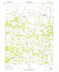
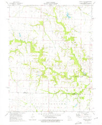
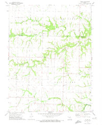 1972 Molino1974 Print · USGSAudrain and Monroe counties are captured here in the early seventies, centered on the South Fork Salt River. Genealogists can trace family footprints at New Hope Cem and Mt Zion Cem or locate the old Hi-Way R-3 Sch.
 - 1972 Map of Auxvasse, 1974 Print
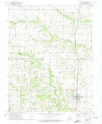 1972 Auxvasse1974 Print · USGSCallaway and Audrain counties are shown in the early seventies during a period of steady rural character. Genealogists can locate family sites near Auxvasse and Concord, or trace the Gulf Central Illinois rail line and Grand Prairie Cem.
 - 1972 Map of Santa Fe, 1974 Print
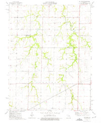
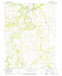 1972 Santa Fe1974 Print · USGSThe rural border of Monroe and Audrain counties comes into focus in the early 1970s, as the river bottom prepares for the waters of a new reservoir. Genealogists and local historians can trace family sites at Eubank Cem, find the small community of Worcester, or locate the numerous Claypits that once defined the local industry.
 - 1972 Map of Mexico SE, 1974 Print
 1972 Mexico SE1974 Print · USGSThe rural borderlands of Audrain and Callaway counties are captured here in the early seventies. Genealogists and local historians can trace family roots through sites like New Hope Cem, the settlement at Watts, and the industrial Claypits.2 unique versions available
 - 1972 Map of Mexico West, 1974 Print
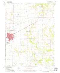
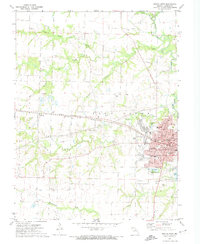 1972 Mexico West1974 Print · USGSThe western edge of Mexico and its surrounding farmstead country are captured here in the early 1970s. Genealogists and local historians can trace the paths of the ILLINOIS CENTRAL GULF railroad and locate family sites near St Brendans Cemetery or the County Farm.2 unique versions available
 - 1973 Map of Farber, 1975 Print
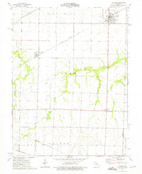
 1973 Farber1975 Print · USGSThe rail towns of Farber and Vandalia are captured in the early 1970s along the Illinois Central Gulf tracks. Researchers can locate family landmarks including Farber Cem, the Drive-in Theater, and Van-Far High Sch.
 - 1973 Map of Martinsburg, 1975 Print
 1973 Martinsburg1975 Print · USGSMartinsburg and the rural crossroads of Shamrock appear in the early 1970s at the meeting of three Missouri counties. Trace the rail-and-river landscape of the day through the Burlington Northern junction, numerous local Claypit mines, and historic sites like Liberty Ch.2 unique versions available
 - 1973 Map of Vandalia Lake, 1975 Print
 1973 Vandalia Lake1975 Print · USGSAudrain and Montgomery Counties were characterized by quiet rural development and water-managed landscapes in the 1970s. Local researchers can trace family landmarks like New Providence Cem, Rices Corner, and the West Cuivre Ch.2 unique versions available
 - 1973 Map of Laddonia, 1975 Print
 1973 Laddonia1975 Print · USGSAudrain County agriculture and transit dominate this mid-seventies landscape near the Montgomery County line. Researchers can trace the intersections of three major railroads and find local landmarks like the R-6 Sch, Rush Hill, and Scotts Corner.
 - 1973 Map of Hutchison, 1975 Print
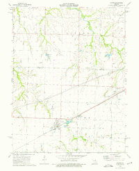
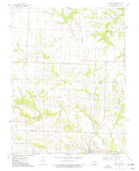
 1973 Hutchison1975 Print · USGSThe rural expanse of Audrain County comes to life in the early 1970s, showcasing the intricate drainage of the Salt River. Genealogists and local historians can trace family roots through landmarks like Hutchison, Prairie View Ch, and Unity Cem.
 - 1973 Map of Middletown, 1977 Print
 1973 Middletown1977 Print · USGSThe tri-county borderlands of Montgomery, Pike, and Audrain counties are detailed here during the early 1970s. Researchers can locate specific rural landmarks like Central Union Ch, the Rudd School, and the Payne Cem along the winding West Fork Cuivre River.
 - 1973 Map of Vandalia, 1977 Print
 1973 Vandalia1977 Print · USGSVandalia and the surrounding townships were crossroads of rail and utility infrastructure in the early 1970s. Genealogists and historians can locate North Sch, trace the Illinois Central Gulf railroad, or find the New Harmony Cem.
End of results
Showing maps 1-13 of 13
Top cities of Audrain County
- Mexico historical maps
- Vandalia historical maps
- Laddonia historical maps
- Farber historical maps
- Martinsburg historical maps
- Rush Hill historical maps
See more
Frequently asked questions
- What are the different types of historical maps available for Audrain County?
- What is the oldest map of Audrain County?
- Where can I purchase historical maps of Audrain County for my home or office?
- Where can I download high-res historical maps of Audrain County?
- Are there historical topographic maps available for Audrain County?
- Is there historical aerial imagery available for Audrain County?
- Where are historical maps of Audrain County sourced from?