1970s Maps of Laddonia, Missouri
Explore 2 historic maps of Laddonia from the 1970s. These maps offer a rare glimpse into what life looked like during the 1970s — showing old roads, neighborhoods, homes, and landmarks that have changed or disappeared over time.
Whether you're researching your family's past, planning a metal detecting trip, or studying how Laddonia's landscape evolved across the 1970s, these high-resolution maps are a powerful tool for exploring the history of this region.
- Focus on a specific era: All maps on this page are from the 1970s, giving you a focused view of this time period.
- See what’s changed: Compare century-old streets, trails, and buildings to today's modern landscape using overlays and satellite layers.
- Research with precision: Use these maps for genealogy, historical research, land use analysis, or educational projects.
- View, download, or print: Maps are fully viewable online in high resolution, and can be downloaded or printed for your own records.
Start exploring Laddonia's history through authentic maps from the 1970s. This is your window into the past.
Laddonia, MO maps
(2)- 1973 Map of Laddonia, 1975 Print
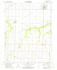 1973 Laddonia1975 Print · USGSAudrain County agriculture and transit dominate this mid-seventies landscape near the Montgomery County line. Researchers can trace the intersections of three major railroads and find local landmarks like the R-6 Sch, Rush Hill, and Scotts Corner.
 - 1973 Map of Hutchison, 1975 Print
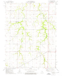 1973 Hutchison1975 Print · USGSThe rural expanse of Audrain County comes to life in the early 1970s, showcasing the intricate drainage of the Salt River. Genealogists and local historians can trace family roots through landmarks like Hutchison, Prairie View Ch, and Unity Cem.
End of results
Showing maps 1-2 of 2
Top cities near Laddonia
- Mexico historical maps
- Vandalia historical maps
- Wellsville historical maps
- Perry historical maps
- Farber historical maps
- Martinsburg historical maps
See more
Frequently asked questions
- What are the different types of historical maps available for Laddonia?
- What is the oldest map of Laddonia?
- Where can I purchase historical maps of Laddonia for my home or office?
- Where can I download high-res historical maps of Laddonia?
- Are there historical topographic maps available for Laddonia?
- Is there historical aerial imagery available for Laddonia?
- Where are historical maps of Laddonia sourced from?