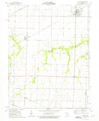
1973 Map of Laddonia
USGS Topo · Published 1975About this map
Laddonia and Rush Hill anchor this rural landscape in the early 1970s, situated at the intersection of critical railroad corridors and prairie drainage systems. The map illustrates a heavy reliance on rail transport, featuring lines from the Illinois Central Gulf, Burlington Northern, and Norfolk and Western. This concentration of infrastructure highlights the area's importance as a shipping point for agricultural goods from the surrounding Prairie and Linn townships.
Find a feature on this map
22 named features on this map. Tap any name to fly to it.
Don’t see what you’re looking for? This feature index may not catch every label — zoom into the map to look around manually.
Map Details
Editions of this 1973 Laddonia Map
This is the sole edition of this map. No revisions or reprints were ever made.
Other maps of this area

1890 · Mexico
USGS Topo · 1:125,000

1932 · Mexico
USGS Topo · 1:62,500

1942 · Wellsville
USGS Topo · 1:62,500

1945 · Florida
USGS Topo · 1:62,500

1945 · Perry
USGS Topo · 1:62,500

1948 · Quincy
USGS Topo · 1:250,000

1956 · Quincy
USGS Topo · 1:250,000
1972 · Mexico East
USGS Topo · 1:24,000
1972 · Santa Fe
USGS Topo · 1:24,000
1972 · Mexico SE
USGS Topo · 1:24,000