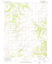
1972 Map of Mexico SE
USGS Topo · Published 1974About this map
The Audrain Co Callaway Co line bisects this 1972 survey, revealing a landscape defined by its complex drainage network and dispersed rural community structures. The northern reach is dominated by the South Fork Salt River and the Timber Lake area, while the southern terrain is carved by Bachelor Creek and Heat String Cr. Small local centers like Watts and the Union Ch appear alongside industrial signatures such as the Claypits near the Loutre River. Genealogical interest is found in the scattered burial grounds that served these agrarian townships, including New Hope Cem, Pleasant Grove Cem, Lockridge Cem, and Unity Cem, each marking a legacy of early settlement along the river forks.
Find a feature on this map
23 named features on this map. Tap any name to fly to it.
Don’t see what you’re looking for? This feature index may not catch every label — zoom into the map to look around manually.
Map Details
Editions of this 1972 Mexico SE Map
2 editions found
Other maps of this area

1890 · Mexico
USGS Topo · 1:125,000

1890 · Fulton
USGS Topo · 1:125,000

1928 · Fulton
USGS Topo · 1:62,500

1931 · Fulton
USGS Topo · 1:62,500

1932 · Mexico
USGS Topo · 1:62,500

1940 · Montgomery City
USGS Topo · 1:62,500

1942 · Montgomery City
USGS Topo · 1:62,500

1942 · Wellsville
USGS Topo · 1:62,500

1948 · Quincy
USGS Topo · 1:250,000

1949 · Saint Louis
USGS Topo · 1:250,000