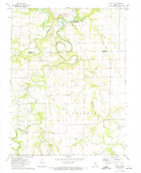
1972 Map of Santa Fe
USGS Topo · Published 1974About this map
Santa Fe sits at the northern edge of this 1970s survey, overlooking the complex oxbows of the South Fork Salt River as it enters the Clarence Cannon Reservoir. The landscape transitions from the river's timbered bottoms into the open Prairie to the south, where the local economy shifted toward resource extraction. Numerous Claypits and smaller claypits are scattered throughout the southern half of the quadrangle, particularly near Littleby Creek and Hazel Creek, indicating a significant local industry during this era.
Find a feature on this map
25 named features on this map. Tap any name to fly to it.
Don’t see what you’re looking for? This feature index may not catch every label — zoom into the map to look around manually.
Map Details
Editions of this 1972 Santa Fe Map
This is the sole edition of this map. No revisions or reprints were ever made.
Other maps of this area

1890 · Mexico
USGS Topo · 1:125,000

1932 · Mexico
USGS Topo · 1:62,500

1942 · Wellsville
USGS Topo · 1:62,500

1945 · Florida
USGS Topo · 1:62,500

1945 · Perry
USGS Topo · 1:62,500

1948 · Quincy
USGS Topo · 1:250,000

1956 · Quincy
USGS Topo · 1:250,000
1972 · Mexico East
USGS Topo · 1:24,000
1972 · Molino
USGS Topo · 1:24,000
1972 · Mexico West
USGS Topo · 1:24,000