1930s Maps of Benton County, Missouri
Explore 7 historic maps of Benton County from the 1930s. These maps offer a rare glimpse into what life looked like during the 1930s — showing old roads, neighborhoods, homes, and landmarks that have changed or disappeared over time.
Whether you're researching your family's past, planning a metal detecting trip, or studying how Benton County's landscape evolved across the 1930s, these high-resolution maps are a powerful tool for exploring the history of this region.
- Focus on a specific era: All maps on this page are from the 1930s, giving you a focused view of this time period.
- See what’s changed: Compare century-old streets, trails, and buildings to today's modern landscape using overlays and satellite layers.
- Research with precision: Use these maps for genealogy, historical research, land use analysis, or educational projects.
- View, download, or print: Maps are fully viewable online in high resolution, and can be downloaded or printed for your own records.
Start exploring Benton County's history through authentic maps from the 1930s. This is your window into the past.
Benton County, MO maps
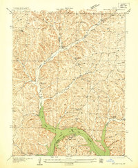
(7)- 1935 Map of Edwards
 1935 Edwards1935 Print · USGSBenton County was adjusting to a transformed landscape in the mid-1930s following the creation of the Lake of the Ozarks. Local historians and genealogists can trace the early shoreline at Duckworths Camp or locate rural landmarks like Rock Spring School and Hastain Ch.
 - 1935 Map of Dell
 1935 Dell1935 Print · USGSBenton County was a landscape of river camps and small school districts during the mid-1930s. Genealogists can locate family landmarks like Old Fredonia, White Cem, and rural schoolhouses including Evening Shade School and Lookout School.
 - 1935 Map of Boylers Mill
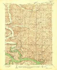
 1935 Boylers Mill1935 Print · USGSThe Morgan and Benton county lines meet here in the 1930s, showing the early impact of the newly formed Lake of the Ozarks. Genealogists can trace family landmarks like the Shiloh Church, Boylers Mill, and several rural one-room schoolhouses.
 - 1935 Map of Knobby Creek
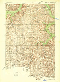 1935 Knobby Creek1935 Print · USGSThe northern Lake of the Ozarks shoreline and its surrounding uplands appear here in the mid-1930s as the reservoir era began. Genealogists can trace rural school districts like Olive Branch School and Nickel Hill School or locate family sites near Dority Cem and Sagrada.2 unique versions available
 - 1936 Map of Shawnee Bend
 1936 Shawnee Bend1936 Print · USGSBenton County was undergoing a massive transformation in the mid-1930s as the newly formed Lake of the Ozarks reshaped the river valleys. Genealogists and local historians can trace family locations near Baugh Cem, the settlement of Racket, and numerous rural schoolhouses like Shawnee Bend Sch.
 - 1936 Map of Lakeview Heights
 1936 Lakeview Heights1936 Print · USGSBenton County landscape during the mid-thirties captures the early shoreline of the Lake of the Ozarks. Researchers can locate several rural landmarks including the Mount Hulda Ch, Mossy Cem, and the vanished Walnut Valley School.2 unique versions available
 - 1936 Map of Schuyler
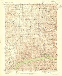 1936 Schuyler1936 Print · USGSBenton County saw a major transformation in the 1930s as the rising waters of the Lake Of The Ozarks reshaped the southern valleys. Genealogists and local historians can trace family locations through numerous rural landmarks like Black Oak Church, Feaster School, and the Bird Cem.
End of results
Showing maps 1-7 of 7
Top cities of Benton County
Frequently asked questions
- What are the different types of historical maps available for Benton County?
- What is the oldest map of Benton County?
- Where can I purchase historical maps of Benton County for my home or office?
- Where can I download high-res historical maps of Benton County?
- Are there historical topographic maps available for Benton County?
- Is there historical aerial imagery available for Benton County?
- Where are historical maps of Benton County sourced from?