1960s Maps of Benton County, Missouri
Explore 10 historic maps of Benton County from the 1960s. These maps offer a rare glimpse into what life looked like during the 1960s — showing old roads, neighborhoods, homes, and landmarks that have changed or disappeared over time.
Whether you're researching your family's past, planning a metal detecting trip, or studying how Benton County's landscape evolved across the 1960s, these high-resolution maps are a powerful tool for exploring the history of this region.
- Focus on a specific era: All maps on this page are from the 1960s, giving you a focused view of this time period.
- See what’s changed: Compare century-old streets, trails, and buildings to today's modern landscape using overlays and satellite layers.
- Research with precision: Use these maps for genealogy, historical research, land use analysis, or educational projects.
- View, download, or print: Maps are fully viewable online in high resolution, and can be downloaded or printed for your own records.
Start exploring Benton County's history through authentic maps from the 1960s. This is your window into the past.
Benton County, MO maps
(10)- 1960 Map of Cross Timbers, 1961 Print
 1960 Cross Timbers1961 Print · USGSThe community of Cross Timbers and the surrounding Hickory County landscape are captured here in the early sixties. Genealogists and local historians can trace family locations near Davis Cem, Bethel Ch, and the waters of Turkey Creek.2 unique versions available
 - 1960 Map of Climax Springs, 1961 Print
 1960 Climax Springs1961 Print · USGSClimax Springs and the Little Niangua River country are captured here at the start of the 1960s, showing a landscape of deep hollows and high ridges. Researchers can trace rural community roots through local landmarks like Wiseman Ch, Green Ridge Cem, and the Climax Springs Lookout Tower.3 unique versions available
 - 1961 Map of Lincoln, 1962 Print
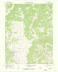
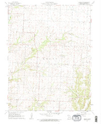
 1961 Lincoln1962 Print · USGSBenton County in the early sixties centers on Lincoln, showing a rural Missouri landscape defined by the Chicago Rock Island and Pacific railroad. Genealogists and historians can locate Zion Ch, Lincoln Cem, and the old Cole Camp Junction rail intersection.2 unique versions available
 - 1961 Map of Pyrmont, 1962 Print
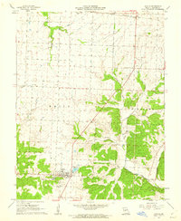
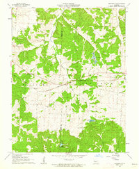
 1961 Pyrmont1962 Print · USGSThe Pettis, Benton, and Morgan county lines meet in this rural Missouri landscape during the early sixties. Genealogists can trace family footprints at St Paul Cem, Lake Creek Ch, and Holy Cross Cem, or locate the Fish Hatchery.
 - 1961 Map of Lincoln NW, 1962 Print
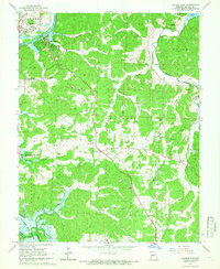
 1961 Lincoln NW1962 Print · USGSBenton County was a landscape of small crossroads and creek valleys in the early sixties. Genealogists and historians can trace rural community life through sites like Santiago, Fairfield Sch, and family burial grounds at Mcintyre Cem.2 unique versions available
 - 1961 Map of Cole Camp, 1962 Print
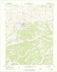 1961 Cole Camp1962 Print · USGSBenton County was a landscape of rail-driven commerce and quiet rural settlements at the start of the sixties. Genealogists and researchers can trace family plots at Cole Camp Memorial Cem or follow the path of the Chicago Rock Island and Pacific through Cole Camp Sta.2 unique versions available
 - 1961 Map of Crockerville, 1962 Print
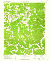
 1961 Crockerville1962 Print · USGSMorgan County rural life is captured here in the early sixties as small communities like Crockerville thrived alongside the Chicago Rock Island and Pacific railroad. Genealogists can trace family roots through the Old Stover Cem or locate the old Brauersville Sch.2 unique versions available
 - 1961 Map of Bahner, 1962 Print
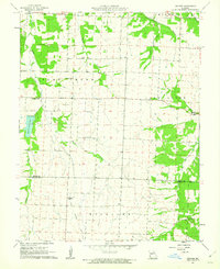 1961 Bahner1962 Print · USGSPettis and Benton Counties are captured in the early sixties, showing a landscape of family-named schools and quiet crossroads. Researchers can trace rural life through the Old Railroad Grade and local landmarks like Lone Star Cem and Prairie Grove Sch.2 unique versions available
 - 1964 Map of Warsaw East, 1966 Print
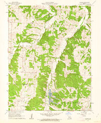
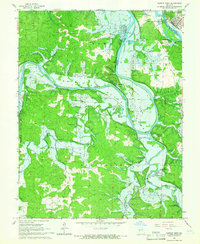
 1964 Warsaw East1966 Print · USGSBenton County is captured in the mid-1960s just as the shoreline was poised to change forever due to dam construction. Researchers can trace family roots at Post Oak Cem and Majorville, or find the old sites of Old Fredonia and Turkey Creek Chapel.3 unique versions available
 - 1965 Map of Warsaw West, 1966 Print
 1965 Warsaw West1966 Print · USGSBenton County was entering a period of major environmental change in the mid-1960s as preparations for a new reservoir began. Genealogists and local historians can trace threatened landmarks like Fairfield, Wisdom Cem, and the Freedom Sch before the landscape was altered.4 unique versions available
End of results
Showing maps 1-10 of 10
Top cities of Benton County
Frequently asked questions
- What are the different types of historical maps available for Benton County?
- What is the oldest map of Benton County?
- Where can I purchase historical maps of Benton County for my home or office?
- Where can I download high-res historical maps of Benton County?
- Are there historical topographic maps available for Benton County?
- Is there historical aerial imagery available for Benton County?
- Where are historical maps of Benton County sourced from?