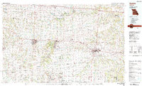
1980s Maps of Benton County, Missouri
Explore 16 historic maps of Benton County from the 1980s. These maps offer a rare glimpse into what life looked like during the 1980s — showing old roads, neighborhoods, homes, and landmarks that have changed or disappeared over time.
Whether you're researching your family's past, planning a metal detecting trip, or studying how Benton County's landscape evolved across the 1980s, these high-resolution maps are a powerful tool for exploring the history of this region.
- Focus on a specific era: All maps on this page are from the 1980s, giving you a focused view of this time period.
- See what’s changed: Compare century-old streets, trails, and buildings to today's modern landscape using overlays and satellite layers.
- Research with precision: Use these maps for genealogy, historical research, land use analysis, or educational projects.
- View, download, or print: Maps are fully viewable online in high resolution, and can be downloaded or printed for your own records.
Start exploring Benton County's history through authentic maps from the 1980s. This is your window into the past.
Benton County, MO maps
(16)- 1980 Map of Shawnee Bend, 1982 Print
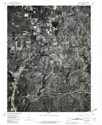
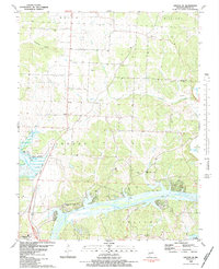
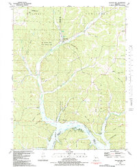
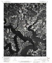 1980 Shawnee Bend1982 Print · USGSBenton County was undergoing a massive transformation in the early eighties as new waters reshaped the landscape. Trace the fingers of the Harry S Truman Reservoir as they reach toward Warsaw and the small settlement at Racket.
 - 1980 Map of Warsaw East, 1982 Print
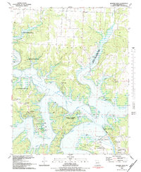
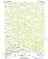
 1980 Warsaw East1982 Print · USGSBenton County undergoes a major geographical shift in the early eighties as new water levels reshape the river valleys. Genealogists and local historians can trace family lands near Whitakerville or follow the winding course of Turkey Creek and the Osage River.
 - 1980 Map of Quincy, 1982 Print
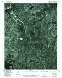
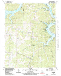
 1980 Quincy1982 Print · USGSHickory County farmsteads and wooded bottomlands are shown in clear aerial detail during the early eighties. Researchers can trace land-use patterns around Bentonville and see the early footprint of the Harry S Truman Reservoir.
 - 1980 Map of Warsaw West, 1982 Print
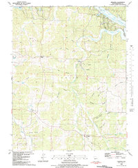
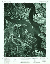 1980 Warsaw West1982 Print · USGSBenton County undergoes a massive transformation in the 1980s as the Osage River valley is inundated. Trace the new shoreline of the Harry S Truman Reservoir and locate local landmarks like Warsaw, Wisdom, and Tackner.
 - 1980 Map of Lincoln SE, 1982 Print
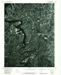
 1980 Lincoln SE1982 Print · USGSBenton County's river landscape is captured here in the early 1980s as major water projects reshaped the valley. Researchers can trace the winding Osage River and the expanding shorelines of the Lake of the Ozarks and Harry S Truman Reservoir.
 - 1980 Map of Fristoe, 1986 Print
 1980 Fristoe1986 Print · USGSHickory County comes into focus in the early eighties through this detailed orthophotoquad. Genealogists and local researchers can trace old road alignments and the precise boundaries of rural settlements like Fristoe, Avery, and White Cloud.
 - 1982 Map of Quincy
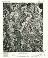
 1982 Quincy1982 Print · USGSHickory and Benton counties are documented here in the early eighties as the landscape adapted to the new Harry S Truman Reservoir. Researchers can trace old family lines through landmarks like Mt Zion Cem, Bentonville, and Pleasant Grove Ch.
 - 1982 Map of Fristoe
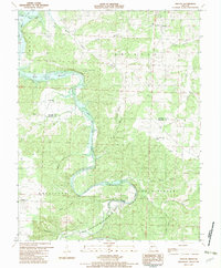 1982 Fristoe1982 Print · USGSThe Pomme de Terre River valley in the early eighties shows a landscape adapting to the new shoreline of the Harry S Truman Reservoir. Local historians can trace family locations at Fristoe and Avery, or find rural landmarks like Spring Branch Ch and South New Home Cem.
 - 1983 Map of Lincoln SE
 1983 Lincoln SE1983 Print · USGSBenton County was entering a new era of water management and recreation in the early 1980s as the Osage River valley was reshaped. Genealogists and historians can trace family locations near Drake Cem, find the Lincoln Lookout Tower, or locate the Sterett Creek Public Use Area.
 - 1983 Map of Shawnee Bend
 1983 Shawnee Bend1983 Print · USGSBenton County was undergoing a massive geographic shift in the early eighties as the new reservoir reshaped the river valleys. Genealogists can locate several family burial sites like Tindle Cem and Lane Cem, or trace older settlements such as Rackett and Macks Camp.
 - 1983 Map of Knobby
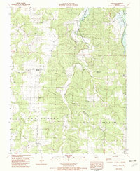
 1983 Knobby1983 Print · USGSThe northern Ozarks landscape is captured here in the early 1980s, where the winding Lake of the Ozarks meets rugged Missouri ridges. Genealogists and hikers can trace old family landmarks like Dority Cemetery, Adkins Cave, and the small settlement of Knobby.
 - 1983 Map of Edwards
 1983 Edwards1983 Print · USGSBenton County's timbered ridges and deep hollows are captured here in the early 1980s, just south of the winding LAKE OF THE OZARKS. Genealogists and historians can trace family roots through landmarks like Jockey City Corners, Belleview Cem, and the community at Edwards.
 - 1983 Map of Sedalia
 1983 Sedalia1983 Print · USGSWest Central Missouri's landscape in the early eighties shows a dense network of rail towns and riverside communities along the Blackwater River. Genealogists and historians can trace the development of Warrensburg and Sedalia near Whiteman Air Force Base and Knob Noster State Park.
 - 1983 Map of Boylers Mill
 1983 Boylers Mill1983 Print · USGSThe northern reaches of the Lake of the Ozarks meet the Missouri Ozarks in the early 1980s, documenting a landscape of steep hollows and family cemeteries. Locate local landmarks like Boylers Mill, the Mt Hulda Lookout Tower, and Shiloh Cem.
 - 1983 Map of Lakeview Heights
 1983 Lakeview Heights1983 Print · USGSBenton County saw a transformation of its river valleys in the early eighties as the shoreline of the reservoir matured. Researchers can trace rural lineages through family-named landmarks like Noel Cem and community centers such as Edmonson Ch and Ozark Tabernacle.
 - 1983 Map of Harry S Truman Reservoir, 1984 Print
 1983 Harry S Truman Reservoir1984 Print · USGSBenton and Henry counties center on the vast Harry S Truman Reservoir in the early 1980s as the landscape adapted to its new shoreline. Genealogists and historians can trace old river crossings like Bledsoe Ferry, local landmarks like Mt Zion Ch, and unique settlements such as Tightwad.
End of results
Showing maps 1-16 of 16
Top cities of Benton County
Frequently asked questions
- What are the different types of historical maps available for Benton County?
- What is the oldest map of Benton County?
- Where can I purchase historical maps of Benton County for my home or office?
- Where can I download high-res historical maps of Benton County?
- Are there historical topographic maps available for Benton County?
- Is there historical aerial imagery available for Benton County?
- Where are historical maps of Benton County sourced from?