1950s Maps of Cedar County, Missouri
Explore 14 historic maps of Cedar County from the 1950s. These maps offer a rare glimpse into what life looked like during the 1950s — showing old roads, neighborhoods, homes, and landmarks that have changed or disappeared over time.
Whether you're researching your family's past, planning a metal detecting trip, or studying how Cedar County's landscape evolved across the 1950s, these high-resolution maps are a powerful tool for exploring the history of this region.
- Focus on a specific era: All maps on this page are from the 1950s, giving you a focused view of this time period.
- See what’s changed: Compare century-old streets, trails, and buildings to today's modern landscape using overlays and satellite layers.
- Research with precision: Use these maps for genealogy, historical research, land use analysis, or educational projects.
- View, download, or print: Maps are fully viewable online in high resolution, and can be downloaded or printed for your own records.
Start exploring Cedar County's history through authentic maps from the 1950s. This is your window into the past.
Cedar County, MO maps
(14)- 1954 Map of Springfield
 1954 Springfield1954 Print · USGSThe Missouri Ozarks are captured here during the post-war era, showing the expansion of Springfield and the surrounding river valleys. Genealogists and historians can trace local landmarks like Mount Comfort Cemetery and the Fort Leonard Wood military grounds.6 unique versions available
 - 1954 Map of Joplin, 1967 Print
 1954 Joplin1967 Print · USGSThe tri-state border region of Kansas, Missouri, and Oklahoma is captured here during a peak era of mid-century industrial and agricultural activity. Researchers can trace family history through dozens of rural cemeteries or locate landmarks like the Kansas Army Ammunition Plant and Pittsburg State University.3 unique versions available
 - 1956 Map of Fair Play, 1957 Print
 1956 Fair Play1957 Print · USGSThe Polk County countryside near Fair Play is captured here in the mid-1950s. Genealogists can locate several family landmarks including Pickel Cem, Dunnegan Cem, and the Woodlawn Sch.2 unique versions available
 - 1956 Map of Stockton, 1957 Print
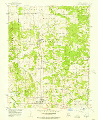
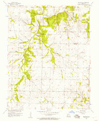
 1956 Stockton1957 Print · USGSMid-century Cedar County is captured here just before major landscape changes, centered on the courthouse town of Stockton. Researchers can trace old family roots at Pankey Cem, visit the settlement of Umber, or locate rural congregations like Gum Springs Ch.3 unique versions available
 - 1956 Map of Bearcreek, 1957 Print
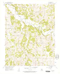
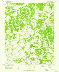
 1956 Bearcreek1957 Print · USGSThe rural borderlands of Cedar and Polk counties are captured here in the mid-1950s, showing a landscape of scattered farmsteads and creek-side settlements. Local historians can trace family roots through landmarks like Friendship Community Hall, Bearcreek, and the Lindley Prairie Ch.3 unique versions available
 - 1956 Map of Bona, 1957 Print
 1956 Bona1957 Print · USGSNear the middle of the twentieth century, this portion of Dade County remained a landscape of riverside bluffs and tight-knit rural communities. Genealogists can trace family roots through numerous sites like Mt Carmel Ch, Fullington Cem, and Masters.3 unique versions available
 - 1956 Map of Cedarville, 1957 Print
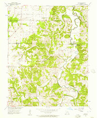
 1956 Cedarville1957 Print · USGSThe borderlands of Cedar and Dade counties are captured here in the mid-1950s, showing a landscape defined by small farmsteads and creek-side settlements. Local historians can trace family locations near Cedarville, Omer, and several rural burial grounds like Hickory Grove Cem.
 - 1956 Map of Crisp, 1957 Print
 1956 Crisp1957 Print · USGSAcross the Cedar and Dade county line in the mid-fifties, this landscape reveals a network of river-bottom farms and rural crossroads. Researchers can locate remote burial sites like Ball Mound Cem and early community centers such as Crisp and Seybert.3 unique versions available
 - 1956 Map of Aldrich, 1957 Print
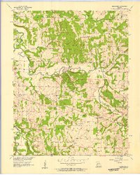
 1956 Aldrich1957 Print · USGSThe river valleys of Polk and Dade Counties are shown here in the mid-1950s, centered on the Little Sac River. Local historians can trace a dense network of family landmarks and rural institutions, from Hubbard Cem to the Bear Creek Quarry.3 unique versions available
 - 1956 Map of Wagoner, 1957 Print
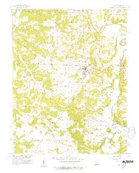
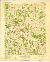
 1956 Wagoner1957 Print · USGSMid-century Cedar County is seen here through its rural school districts and community halls during a period of local consolidation. Genealogists can trace family landmarks like Hamby Cem, Cedar Bluff Cem, and the Sand Ridge Sch (Abandoned).2 unique versions available
 - 1958 Map of Springfield
 1958 Springfield1958 Print · USGSThe Missouri Ozarks are captured during the mid-century era of growth, centered on the bustling hub of Springfield. Genealogists and historians can trace family roots through numerous landmarks like Ebenezer Church, Stockton Cem, and the various county courthouses.
 - 1958 Map of Joplin
 1958 Joplin1958 Print · USGSThe tri-state border region of Missouri, Kansas, and Oklahoma is shown during the late fifties, a time of heavy rail traffic and mining activity. Local historians can trace the industrial landscape through the Joplin & Pittsburg Ry or locate family sites like Zion Ch and Bender Mounds.
 - 1959 Map of Joplin
 1959 Joplin1959 Print · USGSThe Tri-State region’s mining and rail-driven economy is on full display in the late fifties. Genealogists can locate Lead and Zinc Mines near Joplin, family markers at Oak Hill Cem, and military history at Camp Clark.
 - 1959 Map of Springfield
 1959 Springfield1959 Print · USGSThe Missouri Ozarks are captured here during a decade of postwar growth and increasing highway connectivity. Researchers can trace the legacy of the St Louis-San Francisco RR and locate early sites in Springfield, Lebanon, and Mountain Grove.
End of results
Showing maps 1-14 of 14
Top cities of Cedar County
- El Dorado Springs historical maps
- Stockton historical maps
- Jerico Springs historical maps
- Umber View Heights historical maps
Frequently asked questions
- What are the different types of historical maps available for Cedar County?
- What is the oldest map of Cedar County?
- Where can I purchase historical maps of Cedar County for my home or office?
- Where can I download high-res historical maps of Cedar County?
- Are there historical topographic maps available for Cedar County?
- Is there historical aerial imagery available for Cedar County?
- Where are historical maps of Cedar County sourced from?