1990s Maps of Cedar County, Missouri
Explore 8 historic maps of Cedar County from the 1990s. These maps offer a rare glimpse into what life looked like during the 1990s — showing old roads, neighborhoods, homes, and landmarks that have changed or disappeared over time.
Whether you're researching your family's past, planning a metal detecting trip, or studying how Cedar County's landscape evolved across the 1990s, these high-resolution maps are a powerful tool for exploring the history of this region.
- Focus on a specific era: All maps on this page are from the 1990s, giving you a focused view of this time period.
- See what’s changed: Compare century-old streets, trails, and buildings to today's modern landscape using overlays and satellite layers.
- Research with precision: Use these maps for genealogy, historical research, land use analysis, or educational projects.
- View, download, or print: Maps are fully viewable online in high resolution, and can be downloaded or printed for your own records.
Start exploring Cedar County's history through authentic maps from the 1990s. This is your window into the past.
Cedar County, MO maps
(8)- 1991 Map of Tiffin
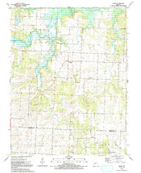 1991 Tiffin1991 Print · USGSIn the early nineties, the borderlands of St. Clair and Cedar counties maintained a quiet rural character defined by the winding Osage River. Researchers can trace historic family landmarks from Tiffin to Cedar Springs, including Landers Cem and Pape Ch.
 - 1991 Map of El Dorado Springs North
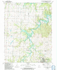 1991 El Dorado Springs North1991 Print · USGSThe rural borderlands of Cedar and St. Clair counties are documented here in the early nineties as El Dorado Springs expanded. Genealogists and historians can locate family landmarks like Lefler Cem, Portia, and the old Railroad Grade.
 - 1991 Map of Arnica
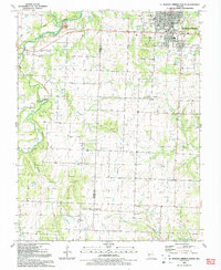
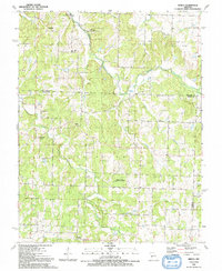 1991 Arnica1991 Print · USGSCedar County in the early nineties remains a landscape of rural crossroads and wildlife conservation areas. Genealogists and local historians can trace family locations near Williams Store, Sneak Cem, and community churches like Brush Creek Ch.
 - 1991 Map of Roscoe
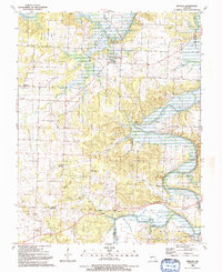 1991 Roscoe1991 Print · USGSThe river bottoms of St. Clair County are captured here in the early nineties as the Osage and Sac Rivers meet. Genealogists and local historians can trace family names and rural landmarks like Love Mound Cem, the Pasley Landing Strip, and the settlement of Crooks Springs.
 - 1991 Map of El Dorado Springs South
 1991 El Dorado Springs South1991 Print · USGSCedar and Vernon Counties were well-established rural communities by the early nineties, centered around agricultural hubs. Genealogists can trace family names and local landmarks through the Virgil City Cemetery, Union Hall Church, and the streets of El Dorado Springs.
 - 1991 Map of Caplinger Mills
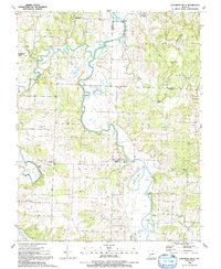 1991 Caplinger Mills1991 Print · USGSCedar County life in the early nineties centers on the winding Sac River and the community at Caplinger Mills. Local researchers can trace family landmarks like Leila Store, Hackleman Cem, and several rural churches including Mt Zion Ch.
 - 1991 Map of Nevada
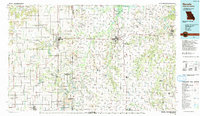 1991 Nevada1991 Print · USGSThis borderland region in the early nineties captures the transition from Kansas plains to Missouri timber. Researchers can trace family history through Bunn Cemetery, locate the Camp Clark Military Reservation, and explore rail towns like Nevada and Fort Scott.
 - 1991 Map of Filley, 1992 Print
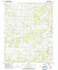 1991 Filley1992 Print · USGSCedar County is mapped here in the early nineties, revealing a dense network of rural churches and family-named cemeteries. Trace local history through Cedar Springs, Pacetown, and landmarks like Hazel Dell Ch.
End of results
Showing maps 1-8 of 8
Top cities of Cedar County
- El Dorado Springs historical maps
- Stockton historical maps
- Jerico Springs historical maps
- Umber View Heights historical maps
Frequently asked questions
- What are the different types of historical maps available for Cedar County?
- What is the oldest map of Cedar County?
- Where can I purchase historical maps of Cedar County for my home or office?
- Where can I download high-res historical maps of Cedar County?
- Are there historical topographic maps available for Cedar County?
- Is there historical aerial imagery available for Cedar County?
- Where are historical maps of Cedar County sourced from?