1940s Maps of Arley, Missouri
Explore 2 historic maps of Arley from the 1940s. These maps offer a rare glimpse into what life looked like during the 1940s — showing old roads, neighborhoods, homes, and landmarks that have changed or disappeared over time.
Whether you're researching your family's past, planning a metal detecting trip, or studying how Arley's landscape evolved across the 1940s, these high-resolution maps are a powerful tool for exploring the history of this region.
- Focus on a specific era: All maps on this page are from the 1940s, giving you a focused view of this time period.
- See what’s changed: Compare century-old streets, trails, and buildings to today's modern landscape using overlays and satellite layers.
- Research with precision: Use these maps for genealogy, historical research, land use analysis, or educational projects.
- View, download, or print: Maps are fully viewable online in high resolution, and can be downloaded or printed for your own records.
Start exploring Arley's history through authentic maps from the 1940s. This is your window into the past.
Arley, MO maps
(2)- 1942 Map of Kearney, 1965 Print
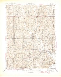
 1942 Kearney1965 Print · USGSClay County at the onset of the 1940s is a landscape of established rail hubs and rural schoolhouses. Genealogists can trace family roots through dozens of local landmarks like Antioch Cem, Mt Gilead Sch, and the County Home.2 unique versions available
 - 1945 Map of Kearney
 1945 Kearney1945 Print · USGSClay County farming communities thrive in the mid-1940s as rail lines connect rural outposts to the wider region. Genealogists can trace family footprints through dozens of local schools like Bodoc Sch and country churches such as Antioch Ch.2 unique versions available
End of results
Showing maps 1-2 of 2
Top cities near Arley
- Kansas City historical maps
- Kansas City historical maps
- Liberty historical maps
- Gladstone historical maps
- Excelsior Springs historical maps
- Kearney historical maps
See more
Frequently asked questions
- What are the different types of historical maps available for Arley?
- What is the oldest map of Arley?
- Where can I purchase historical maps of Arley for my home or office?
- Where can I download high-res historical maps of Arley?
- Are there historical topographic maps available for Arley?
- Is there historical aerial imagery available for Arley?
- Where are historical maps of Arley sourced from?