1990s Maps of Excelsior Springs, Missouri
Explore 3 historic maps of Excelsior Springs from the 1990s. These maps offer a rare glimpse into what life looked like during the 1990s — showing old roads, neighborhoods, homes, and landmarks that have changed or disappeared over time.
Whether you're researching your family's past, planning a metal detecting trip, or studying how Excelsior Springs's landscape evolved across the 1990s, these high-resolution maps are a powerful tool for exploring the history of this region.
- Focus on a specific era: All maps on this page are from the 1990s, giving you a focused view of this time period.
- See what’s changed: Compare century-old streets, trails, and buildings to today's modern landscape using overlays and satellite layers.
- Research with precision: Use these maps for genealogy, historical research, land use analysis, or educational projects.
- View, download, or print: Maps are fully viewable online in high resolution, and can be downloaded or printed for your own records.
Start exploring Excelsior Springs's history through authentic maps from the 1990s. This is your window into the past.
Excelsior Springs, MO maps
(3)- 1990 Map of Kearney, 1996 Print
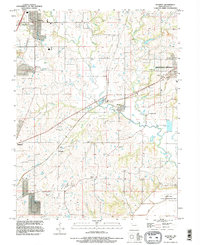 1990 Kearney1996 Print · USGSClay County's rural landscape is shown in the 1990s as suburban growth began reaching toward Kearney and Liberty. Genealogists can trace dozens of family burial sites including Old Liberty Cem, Tapp Cem, and the historic settlement of Stockdale.
 - 1990 Map of Excelsior Springs, 1997 Print
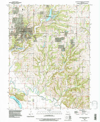 1990 Excelsior Springs1997 Print · USGSExcelsior Springs and its surrounding communities are captured in the 1990s as the suburbs of Kansas City continued their outward reach. Researchers can trace family history through numerous local burial sites like Ellitwood Cem or explore the development around Crystal Lakes and Sunnyside.
 - 1990 Map of Lawson, 1997 Print
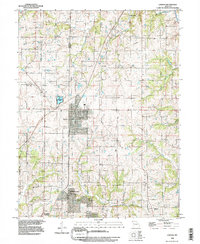 1990 Lawson1997 Print · USGSNorth-central Missouri comes into focus in the 1990s as the town of Lawson straddles the borders of three counties. Genealogists and historians can trace local development through the Cemeteries and older settlements like Vibbard and Elmira Camp.
End of results
Showing maps 1-3 of 3
Top cities near Excelsior Springs
- Kansas City historical maps
- Independence historical maps
- Liberty historical maps
- Kearney historical maps
- Pleasant Valley historical maps
- Buckner historical maps
See more
Top neighborhoods of Excelsior Springs
Frequently asked questions
- What are the different types of historical maps available for Excelsior Springs?
- What is the oldest map of Excelsior Springs?
- Where can I purchase historical maps of Excelsior Springs for my home or office?
- Where can I download high-res historical maps of Excelsior Springs?
- Are there historical topographic maps available for Excelsior Springs?
- Is there historical aerial imagery available for Excelsior Springs?
- Where are historical maps of Excelsior Springs sourced from?