1960s Maps of Crawford County, Missouri
Explore 15 historic maps of Crawford County from the 1960s. These maps offer a rare glimpse into what life looked like during the 1960s — showing old roads, neighborhoods, homes, and landmarks that have changed or disappeared over time.
Whether you're researching your family's past, planning a metal detecting trip, or studying how Crawford County's landscape evolved across the 1960s, these high-resolution maps are a powerful tool for exploring the history of this region.
- Focus on a specific era: All maps on this page are from the 1960s, giving you a focused view of this time period.
- See what’s changed: Compare century-old streets, trails, and buildings to today's modern landscape using overlays and satellite layers.
- Research with precision: Use these maps for genealogy, historical research, land use analysis, or educational projects.
- View, download, or print: Maps are fully viewable online in high resolution, and can be downloaded or printed for your own records.
Start exploring Crawford County's history through authentic maps from the 1960s. This is your window into the past.
Crawford County, MO maps
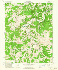
(15)- 1960 Map of Rolla
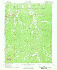
 1960 Rolla1960 Print · USGSThe Ozark Highlands in the mid-twentieth century reveal a landscape of deep timber and heavy industry. Researchers can trace the rail-and-mine economy through the St Louis-San Francisco RR and the Iron Mountain Mine, alongside the growth of Fort Leonard Wood.
 - 1962 Map of St. Louis
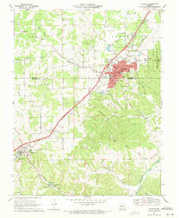
 1962 St. Louis1962 Print · USGSThe mid-century gateway to the west shows the metropolitan expansion of St Louis alongside its critical river confluences. Genealogists and historians can trace the rail corridors of the Missouri Pacific RR and settlements from Fulton to De Soto.
 - 1962 Map of Redbird, 1964 Print
 1962 Redbird1964 Print · USGSGasconade County and the surrounding tri-county border area are captured here in the early sixties, centered on the winding Bourbeuse River. Genealogists can trace family names through numerous burial sites and rural meeting houses, such as Smith Cem, Jackson Cem, and Blue Spring Ch.2 unique versions available
 - 1963 Map of Seaton, 1964 Print
 1963 Seaton1964 Print · USGSPhelps and Dent Counties in the early 1960s were home to dispersed settlements and a network of family-named landmarks. Researchers can trace the legacy of rural life through sites like Seaton, the Hale Sch, and the winding Old Railroad Grade.3 unique versions available
 - 1963 Map of Rosati, 1964 Print
 1963 Rosati1964 Print · USGSPhelps County in the early sixties is captured here as a landscape of rail-fed settlements and active clay mining. Researchers can locate several family burial sites like Atteberry Fort Cem and local institutions like the State Federal Soldiers Home.3 unique versions available
 - 1963 Map of Maramec Spring, 1964 Print
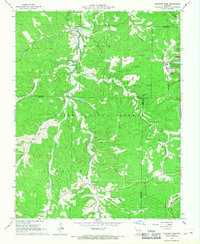
 1963 Maramec Spring1964 Print · USGSPhelps County was a hub of early Ozark industry and rural settlement in the early 1960s. Researchers can trace the legacy of the Old Iron Furnace near Meramec Spring or locate family plots at Hawkins Cem and Pine Hill Cem.4 unique versions available
 - 1963 Map of St. Louis, 1970 Print
 1963 St. Louis1970 Print · USGSSt. Louis and its surrounding river valleys are captured here during the peak of mid-century suburban expansion and industrial activity. Trace the historic rail routes of the Norfolk and Western Ry or locate the St Louis Ordnance Plant and early stretches of US Highway 66.4 unique versions available
 - 1966 Map of Rolla
 1966 Rolla1966 Print · USGSThe Missouri Ozarks are revealed here in the mid-1960s, showing the intersection of heavy industry and sprawling national forests. Trace the development of the Lead Belt near Flat River or locate family roots in vanished hamlets like Enough and Howes Mill.
 - 1966 Map of St. Louis
 1966 St. Louis1966 Print · USGSThe St. Louis metropolitan area and its surrounding river valleys are captured here during the mid-sixties era of suburban growth and industrial strength. Genealogists and historians can trace the foundations of local communities through sites like Old Pioneer Cem, Parks College, and the Jefferson Barracks Military Reservation.
 - 1967 Map of Viburnum East, 1968 Print
 1967 Viburnum East1968 Print · USGSIron and Dent counties are shown here during the 1960s expansion of the Missouri New Lead Belt. Genealogists and local historians can trace the foundations of mining at the Viburnum Mine or locate family sites like Abbott Cem and the West End Sch.5 unique versions available
 - 1967 Map of Viburnum West, 1968 Print
 1967 Viburnum West1968 Print · USGSThe Missouri Ozarks during the mid-sixties reveal a landscape transitioning from timber and farming to industrial mining. Researchers can trace family history at Dillard Cem or locate old industrial infrastructure like the Old Railroad Grade and the St Louis-San Francisco line.5 unique versions available
 - 1969 Map of Sullivan, 1971 Print
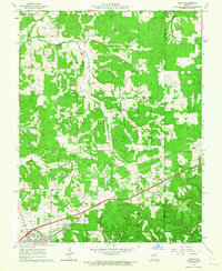
 1969 Sullivan1971 Print · USGSSullivan and Bourbon sit along the St Louis - San Francisco rail line during a period of mid-century growth. Genealogists can locate family landmarks like Turner Cem, Wesleyan Ch, and the old settlements of Oak Grove and St Cloud.2 unique versions available
 - 1969 Map of Onondaga Cave, 1971 Print
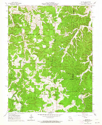
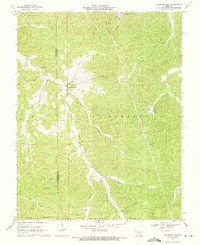
 1969 Onondaga Cave1971 Print · USGSCrawford County at the end of the sixties reveals a landscape of deep river bends and significant karst features. Genealogists and explorers can trace the roads to Vilander, locate family plots at Harrison Cem, and study the topography around Onondaga Cave and Bat Cave.3 unique versions available
 - 1969 Map of Anthonies Mill, 1971 Print
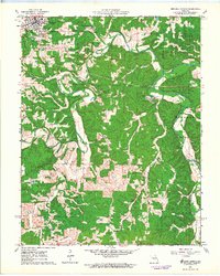
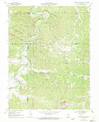
 1969 Anthonies Mill1971 Print · USGSThe Missouri Ozarks during the late 1960s reveal a landscape of secluded hollows and deep-rooted community landmarks along the Crawford and Washington county line. Researchers can locate remote family cemeteries like Swan Cem and Anthonies Cem, or trace the industrial footprint of the Pea Ridge Mine and Old Christ Mine.3 unique versions available
 - 1969 Map of Meramec State Park, 1971 Print
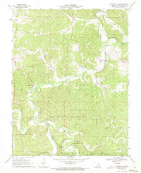
 1969 Meramec State Park1971 Print · USGSThe Meramec River valley in the late sixties reveals a landscape of subterranean wonders and heavy industry. Genealogists and historians can locate rural landmarks like Caseyville and the Pea Ridge Sch or trace the industrial footprint of the Pea Ridge Mine.6 unique versions available
End of results
Showing maps 1-15 of 15
Top cities of Crawford County
- Cuba historical maps
- Steelville historical maps
- Bourbon historical maps
- Leasburg historical maps
- West Sullivan historical maps
Frequently asked questions
- What are the different types of historical maps available for Crawford County?
- What is the oldest map of Crawford County?
- Where can I purchase historical maps of Crawford County for my home or office?
- Where can I download high-res historical maps of Crawford County?
- Are there historical topographic maps available for Crawford County?
- Is there historical aerial imagery available for Crawford County?
- Where are historical maps of Crawford County sourced from?