1990s Maps of Crawford County, Missouri
Explore 8 historic maps of Crawford County from the 1990s. These maps offer a rare glimpse into what life looked like during the 1990s — showing old roads, neighborhoods, homes, and landmarks that have changed or disappeared over time.
Whether you're researching your family's past, planning a metal detecting trip, or studying how Crawford County's landscape evolved across the 1990s, these high-resolution maps are a powerful tool for exploring the history of this region.
- Focus on a specific era: All maps on this page are from the 1990s, giving you a focused view of this time period.
- See what’s changed: Compare century-old streets, trails, and buildings to today's modern landscape using overlays and satellite layers.
- Research with precision: Use these maps for genealogy, historical research, land use analysis, or educational projects.
- View, download, or print: Maps are fully viewable online in high resolution, and can be downloaded or printed for your own records.
Start exploring Crawford County's history through authentic maps from the 1990s. This is your window into the past.
Crawford County, MO maps
(8)- 1999 Map of Viburnum West, 2002 Print
 1999 Viburnum West2002 Print · USGSThe Missouri Ozarks are captured here at the close of the millennium, showing a landscape defined by federal forest lands and the lead industry. Researchers can find old family burial grounds like Maple Grove Cem, the site of Richards Charcoal Kilns, and the historic Dillard Mill State Historical Site.
 - 1999 Map of Berryman, 2002 Print
 1999 Berryman2002 Print · USGSThe Missouri Ozarks are captured here at the end of the century, centered on the Berryman community within the Mark Twain National Forest. Genealogists and hikers can trace the paths of the Ozark Trail, find the Oak Grove Ch, and locate family names at the Caswell Cem.
 - 1999 Map of Huzzah, 2002 Print
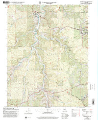
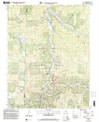
 1999 Huzzah2002 Print · USGSMissouri's Crawford County is shown here at the turn of the millennium, dominated by the dense woodlands of the Mark Twain National Forest. Trace family roots and local landmarks at the Fish Hatchery, Berryman Ch, and numerous family burial grounds like Hefflin Cem.
 - 1999 Map of Viburnum East, 2002 Print
 1999 Viburnum East2002 Print · USGSThe Missouri Lead Belt is captured in detail during the late 1990s, showcasing a landscape defined by heavy industry and small Ozark communities. Researchers can trace mining operations at the Magmont Mine or locate rural family landmarks like Abbott Cemetery and West End School.
 - 1999 Map of Steelville, 2002 Print
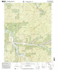
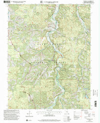
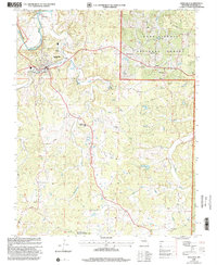 1999 Steelville2002 Print · USGSSteelville and the winding Meramec River valley are captured here at the close of the twentieth century. Genealogists and local historians can trace family locations through numerous sites like Moutray Cem, Midland Ch, and the Midland Mine.
 - 1999 Map of Courtois, 2002 Print
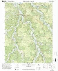
 1999 Courtois2002 Print · USGSThe Missouri Ozarks are captured here at the end of the millennium, showing a landscape of deep hollows and forest service lands. Local historians can trace family sites and rural landmarks like Jinkerson Cem, Sugar Grove Ch, and the Czar Lookout.
 - 1999 Map of Davisville, 2002 Print
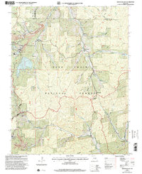
 1999 Davisville2002 Print · USGSThe Huzzah Creek valley in Crawford County is shown here at the close of the twentieth century, deeply integrated into the forest landscape. Genealogists and hikers can trace numerous remote burial sites like Turnbough Cem and landmarks such as Fox Theater Ch.
 - 1999 Map of Howes Mill Spring, 2002 Print
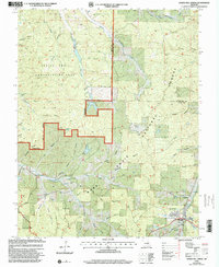 1999 Howes Mill Spring2002 Print · USGSDent County and Crawford County are shown in the late nineties, documenting a landscape of remote hollows and high Ozark ridges. Genealogists and researchers can trace family landmarks like Hutson-Walker Cem, Bowers Cem, and the abandoned fish hatcheries near Howes Mill Spring.
End of results
Showing maps 1-8 of 8
Top cities of Crawford County
- Cuba historical maps
- Steelville historical maps
- Bourbon historical maps
- Leasburg historical maps
- West Sullivan historical maps
Frequently asked questions
- What are the different types of historical maps available for Crawford County?
- What is the oldest map of Crawford County?
- Where can I purchase historical maps of Crawford County for my home or office?
- Where can I download high-res historical maps of Crawford County?
- Are there historical topographic maps available for Crawford County?
- Is there historical aerial imagery available for Crawford County?
- Where are historical maps of Crawford County sourced from?