1980s Maps of Dade County, Missouri
Explore 4 historic maps of Dade County from the 1980s. These maps offer a rare glimpse into what life looked like during the 1980s — showing old roads, neighborhoods, homes, and landmarks that have changed or disappeared over time.
Whether you're researching your family's past, planning a metal detecting trip, or studying how Dade County's landscape evolved across the 1980s, these high-resolution maps are a powerful tool for exploring the history of this region.
- Focus on a specific era: All maps on this page are from the 1980s, giving you a focused view of this time period.
- See what’s changed: Compare century-old streets, trails, and buildings to today's modern landscape using overlays and satellite layers.
- Research with precision: Use these maps for genealogy, historical research, land use analysis, or educational projects.
- View, download, or print: Maps are fully viewable online in high resolution, and can be downloaded or printed for your own records.
Start exploring Dade County's history through authentic maps from the 1980s. This is your window into the past.
Dade County, MO maps
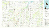
(4)- 1982 Map of Springfield, 1983 Print
 1982 Springfield1983 Print · USGSSpringfield and the surrounding Ozark plateau are captured in the early eighties as the region balanced urban growth with its agricultural roots. Genealogists and researchers can trace the locations of White Chapel, the State Sanatorium, and older rail stops like Brookline.
 - 1984 Map of Bolivar
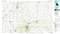
 1984 Bolivar1984 Print · USGSWestern Missouri in the mid-eighties shows a landscape shaped by large-scale water management and rail commerce. Genealogists and historians can trace the development of towns like Bolivar and El Dorado Springs alongside the massive Stockton Lake.
 - 1986 Map of Nevada
 1986 Nevada1986 Print · USGSThe Missouri-Kansas borderlands in the mid-1980s show a landscape of active rail lines and coal mining. Researchers can trace the Old Military Road or locate family plots in the National Cemetery and Deepwood Cemetery.
 - 1986 Map of Joplin
 1986 Joplin1986 Print · USGSThe tri-state border region comes alive in the mid-eighties as an industrial and transit powerhouse where Kansas and Missouri meet. Researchers can trace the heavy rail influence of the Missouri Pacific RR and explore sites like the Mined Land State Wildlife Area.
End of results
Showing maps 1-4 of 4
Top cities of Dade County
- Greenfield historical maps
- Lockwood historical maps
- Everton historical maps
- Dadeville historical maps
- Pilgrim historical maps
- South Greenfield historical maps
See more
Frequently asked questions
- What are the different types of historical maps available for Dade County?
- What is the oldest map of Dade County?
- Where can I purchase historical maps of Dade County for my home or office?
- Where can I download high-res historical maps of Dade County?
- Are there historical topographic maps available for Dade County?
- Is there historical aerial imagery available for Dade County?
- Where are historical maps of Dade County sourced from?