1960s Maps of Dade County, Missouri
Explore 3 historic maps of Dade County from the 1960s. These maps offer a rare glimpse into what life looked like during the 1960s — showing old roads, neighborhoods, homes, and landmarks that have changed or disappeared over time.
Whether you're researching your family's past, planning a metal detecting trip, or studying how Dade County's landscape evolved across the 1960s, these high-resolution maps are a powerful tool for exploring the history of this region.
- Focus on a specific era: All maps on this page are from the 1960s, giving you a focused view of this time period.
- See what’s changed: Compare century-old streets, trails, and buildings to today's modern landscape using overlays and satellite layers.
- Research with precision: Use these maps for genealogy, historical research, land use analysis, or educational projects.
- View, download, or print: Maps are fully viewable online in high resolution, and can be downloaded or printed for your own records.
Start exploring Dade County's history through authentic maps from the 1960s. This is your window into the past.
Dade County, MO maps
(3)- 1962 Map of Jerico Springs, 1963 Print
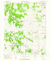 1962 Jerico Springs1963 Print · USGSThe rural borderlands of Cedar, Barton, and Dade Counties are captured here in the early sixties. Genealogists and local historians can locate family landmarks such as Round Prairie Sch, Greenfield Cem, and the church at Stony Point Ch.2 unique versions available
 - 1962 Map of Dudenville, 1963 Print
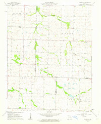 1962 Dudenville1963 Print · USGSSouthwest Missouri farmland and rural townships are captured here in the early 1960s at the junction of four counties. Genealogists and local historians can trace the foundations of Dudenville, the location of Unity Sch, and the grounds of Kistler Cem.2 unique versions available
 - 1962 Map of Golden City, 1964 Print
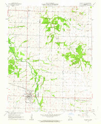 1962 Golden City1964 Print · USGSBarton and Dade counties come to life in the early sixties, showing a landscape defined by the Frisco railroad and the prairie. Trace family roots at Harlow-Wright Cem or explore the rural layout of Layneville and the industrial Strip Mines.
End of results
Showing maps 1-3 of 3
Top cities of Dade County
- Greenfield historical maps
- Lockwood historical maps
- Everton historical maps
- Dadeville historical maps
- Pilgrim historical maps
- South Greenfield historical maps
See more
Frequently asked questions
- What are the different types of historical maps available for Dade County?
- What is the oldest map of Dade County?
- Where can I purchase historical maps of Dade County for my home or office?
- Where can I download high-res historical maps of Dade County?
- Are there historical topographic maps available for Dade County?
- Is there historical aerial imagery available for Dade County?
- Where are historical maps of Dade County sourced from?