1980s Maps of Dallas County, Missouri
Explore 14 historic maps of Dallas County from the 1980s. These maps offer a rare glimpse into what life looked like during the 1980s — showing old roads, neighborhoods, homes, and landmarks that have changed or disappeared over time.
Whether you're researching your family's past, planning a metal detecting trip, or studying how Dallas County's landscape evolved across the 1980s, these high-resolution maps are a powerful tool for exploring the history of this region.
- Focus on a specific era: All maps on this page are from the 1980s, giving you a focused view of this time period.
- See what’s changed: Compare century-old streets, trails, and buildings to today's modern landscape using overlays and satellite layers.
- Research with precision: Use these maps for genealogy, historical research, land use analysis, or educational projects.
- View, download, or print: Maps are fully viewable online in high resolution, and can be downloaded or printed for your own records.
Start exploring Dallas County's history through authentic maps from the 1980s. This is your window into the past.
Dallas County, MO maps
(14)- 1982 Map of Niangua, 1983 Print
 1982 Niangua1983 Print · USGSThis part of Webster and Laclede counties in the early eighties shows a landscape of small Ozark settlements and timbered state lands. Researchers can locate family landmarks like Letterman Cem, the village of Niangua, and rural churches such as Mathis Ch.
 - 1982 Map of Windyville, 1983 Print
 1982 Windyville1983 Print · USGSIn the early 1980s, the Niangua River valley in Dallas County maintained a quiet rural character centered on the settlement of Windyville. Researchers can trace deep family roots through numerous local burial grounds like Scrivner and Fourmile cemeteries or explore the river terrain near Kehler Bluff.
 - 1982 Map of Eldridge West, 1983 Print
 1982 Eldridge West1983 Print · USGSLaclede and Dallas counties appear as a network of deep-cut hollows and river bluffs in the early 1980s. Researchers can trace family lines and old homestead sites at Ballard Cem, Guthrie Cem, and the quiet crossing at Ira.
 - 1982 Map of Phillipsburg, 1983 Print
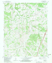
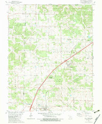 1982 Phillipsburg1983 Print · USGSPhillipsburg and Conway are captured in the early eighties as the railroad still serves as a central artery for these Missouri communities. Researchers can locate numerous family-named landmarks and rural burial sites like Shanks Cem, Lonesome Hill Cem, and Mt Zion Ch.
 - 1982 Map of Bennett Springs, 1983 Print
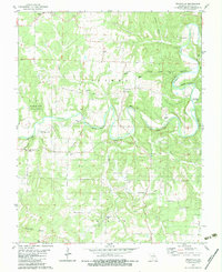
 1982 Bennett Springs1983 Print · USGSThe Niangua River valley and the Laclede county line are documented here in the early eighties. Researchers can trace deep local roots at Bennett Cem, Atchley-Blackfoot Cem, and the Flatwoods Ch community.
 - 1982 Map of Long Lane, 1983 Print
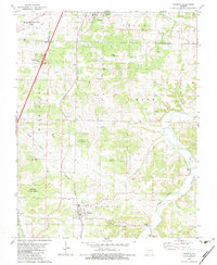
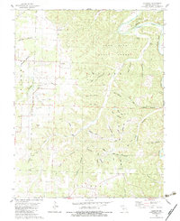
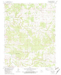 1982 Long Lane1983 Print · USGSDallas County, Missouri, is captured here in the early eighties, showcasing a rural landscape of winding creek beds and family-run farms. Genealogists and local historians can trace connections to Long Lane and Earnestville or locate family sites at Hill Cem and Harris Cem.
 - 1982 Map of Springfield, 1983 Print
 1982 Springfield1983 Print · USGSSpringfield and the surrounding Ozark plateau are captured in the early eighties as the region balanced urban growth with its agricultural roots. Genealogists and researchers can trace the locations of White Chapel, the State Sanatorium, and older rail stops like Brookline.
 - 1982 Map of Beach, 1983 Print
 1982 Beach1983 Print · USGSThe Niangua River valley and its timbered uplands define this Missouri landscape in the early eighties. Local researchers can trace family roots through Thorpe Cem and Marlin Cem or locate old community centers like Beach and Forkners Hill.
 - 1982 Map of Macks Creek, 1983 Print
 1982 Macks Creek1983 Print · USGSThe Missouri Ozarks are captured here in the early 1980s as the rugged terrain of the Camden and Dallas county line remained deeply rural. Genealogists can trace local roots through the Wiley Gott Cem, Mission Ridge Ch, and the small community of Celt.
 - 1982 Map of Hahatonka, 1983 Print
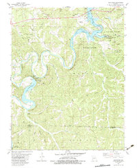 1982 Hahatonka1983 Print · USGSThe Lake of the Ozarks region in the early 1980s reveals a rugged landscape of river bluffs and hydroelectric development. Genealogists and hikers can locate the Ruins and Natural Bridge at Ha Ha Tonka State Park or trace family sites like Dickerson Cem.2 unique versions available
 - 1982 Map of Lebanon, 1983 Print
 1982 Lebanon1983 Print · USGSThe Missouri Ozarks are captured in the early eighties as Interstate 44 and the St Louis-San Francisco rail line link growing towns with the Fort Leonard Wood Military Reservation. Genealogists and historians can trace family-named sites like Flatwood Church and old post offices at Sleeper and Nebo.
 - 1982 Map of Leadmine, 1983 Print
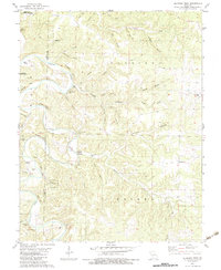
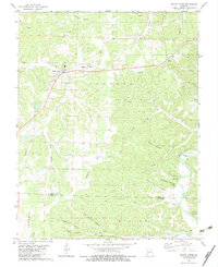
 1982 Leadmine1983 Print · USGSDallas County in the early eighties reveals a river-centered landscape shaped by lead extraction and forestry. Genealogists and historians can trace community roots through Leadmine and country landmarks like Kirk Chapel, Pleasant Hill Ch, and the Rambo Mine.
 - 1983 Map of Mountain Grove
 1983 Mountain Grove1983 Print · USGSWright and Webster counties in the early 1980s show a traditional Ozark landscape of ridge-running railroads and river headwaters. You can trace the Burlington Northern Railroad through towns like Mansfield or find rural landmarks like Vance Cem and Mt Zion Church.
 - 1984 Map of Bolivar
 1984 Bolivar1984 Print · USGSWestern Missouri in the mid-eighties shows a landscape shaped by large-scale water management and rail commerce. Genealogists and historians can trace the development of towns like Bolivar and El Dorado Springs alongside the massive Stockton Lake.
End of results
Showing maps 1-14 of 14
Top cities of Dallas County
Frequently asked questions
- What are the different types of historical maps available for Dallas County?
- What is the oldest map of Dallas County?
- Where can I purchase historical maps of Dallas County for my home or office?
- Where can I download high-res historical maps of Dallas County?
- Are there historical topographic maps available for Dallas County?
- Is there historical aerial imagery available for Dallas County?
- Where are historical maps of Dallas County sourced from?