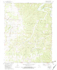
1982 Map of Leadmine
USGS Topo · Published 1983About this map
Leadmine is the central settlement in this portion of Dallas County, situated in a landscape defined by the deep incisions of the Niangua River and its tributary, the Little Niangua River. The area’s history is tied to the earth, as seen in the presence of the Rambo Mine and the extensive Lead Mine State Forest, which occupies the high ridges above the river bluffs. This 1980s-era topography shows a rural community organized around water and relief, with family-named landmarks like Webster Bluff and Turner Bluff rising sharply from the riverbanks. The social fabric of the era is anchored by small country churches, including Kirk Chapel, Pleasant Hill Ch, and Bailey Chapel. Rugged hollows such as Smelter Hollow and Sawmill Hollow point to a legacy of localized extraction and timbering that shaped the region's early development.
Find a feature on this map
53 named features on this map. Tap any name to fly to it.
Don’t see what you’re looking for? This feature index may not catch every label — zoom into the map to look around manually.
Map Details
Editions of this 1982 Leadmine Map
This is the sole edition of this map. No revisions or reprints were ever made.
Other maps of this area

1884 · Bolivar
USGS Topo · 1:125,000

1892 · Bolivar
USGS Topo · 1:125,000

1934 · Macks Creek
USGS Topo · 1:48,000

1939 · Macks Creek
USGS Topo · 1:62,500

1939 · Long Lane
USGS Topo · 1:62,500

1942 · Long Lane
USGS Topo · 1:62,500

1954 · Springfield
USGS Topo · 1:250,000

1958 · Springfield
USGS Topo · 1:250,000

1959 · Springfield
USGS Topo · 1:250,000
1960 · Branch
USGS Topo · 1:24,000