1970s Maps of Douglas County, Missouri
Explore 12 historic maps of Douglas County from the 1970s. These maps offer a rare glimpse into what life looked like during the 1970s — showing old roads, neighborhoods, homes, and landmarks that have changed or disappeared over time.
Whether you're researching your family's past, planning a metal detecting trip, or studying how Douglas County's landscape evolved across the 1970s, these high-resolution maps are a powerful tool for exploring the history of this region.
- Focus on a specific era: All maps on this page are from the 1970s, giving you a focused view of this time period.
- See what’s changed: Compare century-old streets, trails, and buildings to today's modern landscape using overlays and satellite layers.
- Research with precision: Use these maps for genealogy, historical research, land use analysis, or educational projects.
- View, download, or print: Maps are fully viewable online in high resolution, and can be downloaded or printed for your own records.
Start exploring Douglas County's history through authentic maps from the 1970s. This is your window into the past.
Douglas County, MO maps
(12)- 1973 Map of Rockbridge, 1975 Print
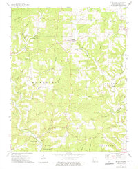
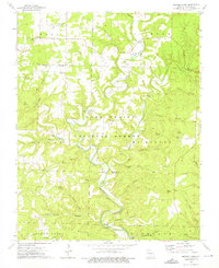
 1973 Rockbridge1975 Print · USGSCrossing the Douglas and Ozark county line in the early 1970s, this area shows a landscape of deep hollows and active spring systems. Local historians can trace the foundations of Rockbridge, locate the Assumption Abbey, or find family landmarks like Walker Knob and Yates Cem.
 - 1973 Map of Brushyknob, 1975 Print
 1973 Brushyknob1975 Print · USGSDouglas County communities and deep Ozark hollows define this area in the early seventies, just as modern conservation efforts were taking shape. Genealogists and hikers can trace local landmarks like Vera Cruz, Brushyknob Ch, and the Skyline Sch.
 - 1973 Map of Vanzant, 1975 Print
 1973 Vanzant1975 Print · USGSDouglas County in the 1970s remained a landscape of quiet Ozark hollows and forest ridges. Genealogists can trace family roots through numerous country landmarks like Pleasant Home Ch, Cali Cem, and the small settlements of Vanzant and Drury.
 - 1973 Map of Gentryville, 1975 Print
 1973 Gentryville1975 Print · USGSThe Douglas and Ozark County borderlands come into focus in the 1970s, showing a landscape defined by winding hollows and small rural congregations. Researchers can locate historic family burial grounds like Eaton Cem and trace the roads connecting Gentryville to Blackjack Ch.
 - 1973 Map of Dora, 1976 Print
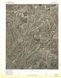
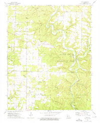 1973 Dora1976 Print · USGSDora and the North Fork White River corridor appear here in the early seventies, spanning the border of Douglas and Ozark counties. Researchers can trace rural cemeteries like Fish and Cudworth Cem, or locate landmarks like Twin Bridges and Hammonds Mill Camp.3 unique versions available
 - 1973 Map of Dyestone Mountain, 1976 Print
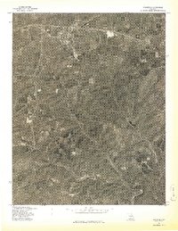
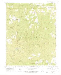 1973 Dyestone Mountain1976 Print · USGSThe Ozark woodlands of Howell and Douglas Counties are captured here in the early 1970s, showcasing a landscape of isolated springs and national forest peaks. Researchers can locate the Pine Grove Sch, the Blue Buck Lookout Tower, and the waters of Noblett Lake.
 - 1973 Map of Siloam Springs, 1976 Print
 1973 Siloam Springs1976 Print · USGSThe Missouri Ozarks are captured here in the early 1970s, showing the intersection of Douglas and Howell counties within the Mark Twain National Forest. Genealogists and local historians can trace family sites like Mitts Cem and Thornton Cem, or locate landmarks such as the Siloam Lookout Tower and Tabor Cave.
 - 1973 Map of Nichols Knob, 1976 Print
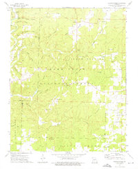
 1973 Nichols Knob1976 Print · USGSDouglas County’s deep hollows and forest ridges are documented here in the early 1970s as the river economy of the Ozarks persisted. Genealogists and hikers can trace the paths to Topaz, Bittick Cem, and local landmarks like Nichols Knob and Mt Ararat Ch.
 - 1977 Map of Norwood
 1977 Norwood1977 Print · USGSThe rural landscape of Wright County is captured in the late seventies through this detailed aerial survey. Genealogists and local historians can trace the specific layouts of old farmsteads and rural routes connecting Norwood and Macomb.
 - 1977 Map of Mansfield
 1977 Mansfield1977 Print · USGSThe town of Mansfield and its surrounding countryside are captured in this late-seventies aerial survey. Researchers can trace land clearing patterns and rural homesteads near the winding course of Bryant Creek during this era of Missouri history.
 - 1977 Map of Cedar Gap
 1977 Cedar Gap1977 Print · USGSThe Missouri Ozarks are shown in transition during the late seventies, documented through detailed aerial orthophotography. Trace the rural landscape around Cedar Gap and Mt Zion or follow the winding course of Bryant Creek.
 - 1977 Map of Mountain Grove South
 1977 Mountain Grove South1977 Print · USGSSouthern Mountain Grove and the surrounding farmsteads are captured in detail during the late seventies. Researchers can trace land boundaries, woodlots, and the growth of the town beyond the city center in this Missouri aerial survey.
End of results
Showing maps 1-12 of 12
Top cities of Douglas County
Frequently asked questions
- What are the different types of historical maps available for Douglas County?
- What is the oldest map of Douglas County?
- Where can I purchase historical maps of Douglas County for my home or office?
- Where can I download high-res historical maps of Douglas County?
- Are there historical topographic maps available for Douglas County?
- Is there historical aerial imagery available for Douglas County?
- Where are historical maps of Douglas County sourced from?