1980s Maps of Douglas County, Missouri
Explore 13 historic maps of Douglas County from the 1980s. These maps offer a rare glimpse into what life looked like during the 1980s — showing old roads, neighborhoods, homes, and landmarks that have changed or disappeared over time.
Whether you're researching your family's past, planning a metal detecting trip, or studying how Douglas County's landscape evolved across the 1980s, these high-resolution maps are a powerful tool for exploring the history of this region.
- Focus on a specific era: All maps on this page are from the 1980s, giving you a focused view of this time period.
- See what’s changed: Compare century-old streets, trails, and buildings to today's modern landscape using overlays and satellite layers.
- Research with precision: Use these maps for genealogy, historical research, land use analysis, or educational projects.
- View, download, or print: Maps are fully viewable online in high resolution, and can be downloaded or printed for your own records.
Start exploring Douglas County's history through authentic maps from the 1980s. This is your window into the past.
Douglas County, MO maps
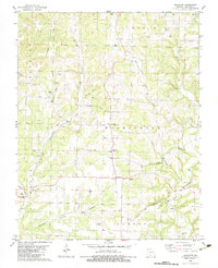
(13)- 1982 Map of Smallett, 1983 Print
 1982 Smallett1983 Print · USGSThe Ozark hill country of Douglas and Ozark Counties is documented here in the early eighties. Genealogists can trace family names at Krider Cem, Walnut Grove Ch, and the settlement of Smallett.
 - 1982 Map of Keltner, 1983 Print
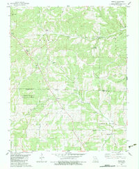
 1982 Keltner1983 Print · USGSThe rural Ozarks on the Christian and Douglas County line appear here in the early eighties as a network of creek-bottom settlements and upland ridges. Genealogists can trace family landmarks like Harvill Cem, Old Merritt, and Union Hill Ch near the banks of Swan Creek.
 - 1982 Map of Dogwood, 1983 Print
 1982 Dogwood1983 Print · USGSThe Ozark highlands of the Webster and Douglas county border are captured here in the early eighties. Genealogists can trace family names through numerous rural burial sites like Cardwell Cem and Silvey Cem or locate the community center of Dogwood.
 - 1982 Map of Bruner, 1983 Print
 1982 Bruner1983 Print · USGSOzark hill country at the intersection of Christian, Webster, and Douglas Counties is captured here in the early eighties. Genealogists and local historians can trace small communities like Bruner and Elkhead alongside landmarks such as Swearengin Cem and Honey Branch Caves.
 - 1982 Map of Ava, 1983 Print
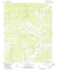
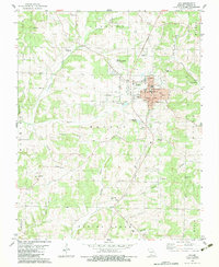 1982 Ava1983 Print · USGSAva and the surrounding Douglas County countryside are captured in the early 1980s as the town expanded around its historic center. Genealogists can trace family roots at Tower Hill Cem and Harris Cem or locate old congregations like Mt Tabor Ch.
 - 1982 Map of Goodhope, 1983 Print
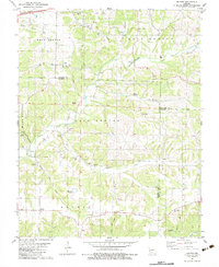
 1982 Goodhope1983 Print · USGSDouglas County in the early eighties is mapped here as a land of quiet Ozark valleys and family-named hollows. Genealogists can trace deep roots through remote landmarks like Goodhope Cem, Huffman Cem, and the historic Jackson Mill.
 - 1982 Map of Wasola, 1983 Print
 1982 Wasola1983 Print · USGSOzark and Douglas counties are documented in the early 1980s, showing a landscape of deep hollows and upland ridges. Genealogists can trace family names at Hilo Cem, Oak Grove Ch, and the small settlement of Wasola.
 - 1982 Map of Bradleyville, 1983 Print
 1982 Bradleyville1983 Print · USGSThe area around Bradleyville in the early eighties remains a landscape of deep hollows and creek-side settlements. Researchers can locate several family burial grounds like Roller Cem and Blair Cem, or trace early industry at the Charcoal Ovens.
 - 1982 Map of Sweden, 1983 Print
 1982 Sweden1983 Print · USGSOzark ridge and valley life in the early 1980s is captured here, centered on the Crystal Spring Fish Hatchery and the small settlement of Sweden. Genealogists can trace family landmarks like Star Chapel, Billingly Cem, and Dyer Cem.
 - 1982 Map of Brownbranch, 1983 Print
 1982 Brownbranch1983 Print · USGSThe Ozark foothills of Douglas and Taney counties are shown in the late seventies, centered on the rural crossroads of Brownbranch. Genealogists and local historians can trace family locations through numerous sites like Summers Cem, Union Grove Ch, and the Plainview R-8 Sch.
 - 1983 Map of Mountain Grove
 1983 Mountain Grove1983 Print · USGSWright and Webster counties in the early 1980s show a traditional Ozark landscape of ridge-running railroads and river headwaters. You can trace the Burlington Northern Railroad through towns like Mansfield or find rural landmarks like Vance Cem and Mt Zion Church.
 - 1985 Map of Ava
 1985 Ava1985 Print · USGSThe Missouri Ozarks are captured here in the mid-1980s, showcasing a landscape of high ridges and deep river hollows. Genealogists and historians can trace family roots through numerous rural settlements like Vera Cruz, Rockbridge, and Almartha, or locate landmarks such as Hercules Tower.
 - 1985 Map of Harrison
 1985 Harrison1985 Print · USGSThe Ozark highlands and the White River valley are seen here in the mid-1980s, showcasing a region defined by its massive reservoirs and protected wilderness. You can trace the rugged corridors of the Missouri & North Arkansas RR or locate historic settlements like Eureka Springs and Jasper.
End of results
Showing maps 1-13 of 13
Top cities of Douglas County
Frequently asked questions
- What are the different types of historical maps available for Douglas County?
- What is the oldest map of Douglas County?
- Where can I purchase historical maps of Douglas County for my home or office?
- Where can I download high-res historical maps of Douglas County?
- Are there historical topographic maps available for Douglas County?
- Is there historical aerial imagery available for Douglas County?
- Where are historical maps of Douglas County sourced from?