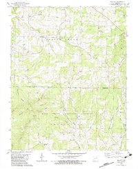
1982 Map of Smallett
USGS Topo · Published 1983About this map
The Mark Twain National Forest dominates the southern half of this landscape, where the Gladetop Trail follows the high ridges between Waterhole Hollow and Sugar Tree Hollow. This early 1980s survey captures a rural landscape defined by narrow creek valleys and named high points like Haden Bald and Coon Knob Hill. The settlement of Smallett sits at the headwaters of Spring Creek, while the community of Toledo is tucked further south near the Little North Fork White River.
Find a feature on this map
36 named features on this map. Tap any name to fly to it.
Don’t see what you’re looking for? This feature index may not catch every label — zoom into the map to look around manually.
Map Details
Editions of this 1982 Smallett Map
This is the sole edition of this map. No revisions or reprints were ever made.
Other maps of this area

1936 · Thornfield
USGS Topo · 1:48,000

1936 · Ava
USGS Topo · 1:48,000

1937 · Bradleyville
USGS Topo · 1:48,000

1942 · Ava
USGS Topo · 1:62,500

1943 · Protem
USGS Topo · 1:62,500

1943 · Thornfield
USGS Topo · 1:62,500

1943 · Bradleyville
USGS Topo · 1:62,500

1945 · Ava
USGS Topo · 1:62,500

1945 · Harrison
USGS Topo · 1:250,000

1945 · Thornfield
USGS Topo · 1:62,500