
1945 Map of Thornfield
USGS Topo · Published 1945About this map
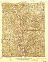
Thornfield and the Little North Fork White River valley serve as the center of this Ozark County landscape, as documented by the Missouri Geological Survey and Water Resources. The 1945 map reveals a rural economy deeply integrated with the river, characterized by numerous river crossings such as Mayhan Ford, Neasby Ford, and Turnbull Ford. These fords and nearby settlements like Theodosia and Isabella represent the area's connectivity before major 20th-century water management projects altered the river's character.
Find a feature on this map
73 named features on this map. Tap any name to fly to it.
Don’t see what you’re looking for? This feature index may not catch every label — zoom into the map to look around manually.
Map Details
Editions of this 1945 Thornfield Map
2 editions found
Other maps of this area

1890 · Mountain Home
USGS Topo · 1:125,000

1891 · Mountain Home
USGS Topo · 1:125,000

1893 · Yellville
USGS Topo · 1:125,000

1894 · Mountain Home
USGS Topo · 1:125,000

1903 · Yellville
USGS Topo · 1:125,000

1905 · Yellville
USGS Topo · 1:125,000

1929 · Yellville
USGS Topo · 1:125,000

1934 · Gainesville
USGS Topo · 1:48,000

1936 · Thornfield
USGS Topo · 1:48,000

1936 · Ava
USGS Topo · 1:48,000